You are here: Home > Network List > IW - Intermountain West Stations List
> Station DLMT Dillon, Montana, USA > Earthquake Result Viewer
DLMT Dillon, Montana, USA - Earthquake Result Viewer
| Earthquake location: |
Mariana Islands |
| Earthquake latitude/longitude: |
18.5/145.5 |
| Earthquake time(UTC): |
2016/07/29 (211) 21:18:25 GMT |
| Earthquake Depth: |
212 km |
| Earthquake Magnitude: |
7.7 MWW, 7.7 MWB, 7.7 MI |
| Earthquake Catalog/Contributor: |
NEIC PDE/NEIC COMCAT |
|
| Network: |
IW Intermountain West |
| Station: |
DLMT Dillon, Montana, USA |
| Lat/Lon: |
45.36 N/112.60 W |
| Elevation: |
1569 m |
|
| Distance: |
85.1 deg |
| Az: |
43.828 deg |
| Baz: |
291.245 deg |
| Ray Param: |
0.044529732 |
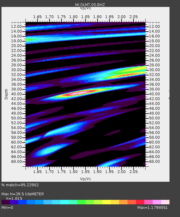
| Estimated Moho Depth: |
39.5 km |
| Estimated Crust Vp/Vs: |
1.82 |
| Assumed Crust Vp: |
6.577 km/s |
| Estimated Crust Vs: |
3.624 km/s |
| Estimated Crust Poisson's Ratio: |
0.28 |
|
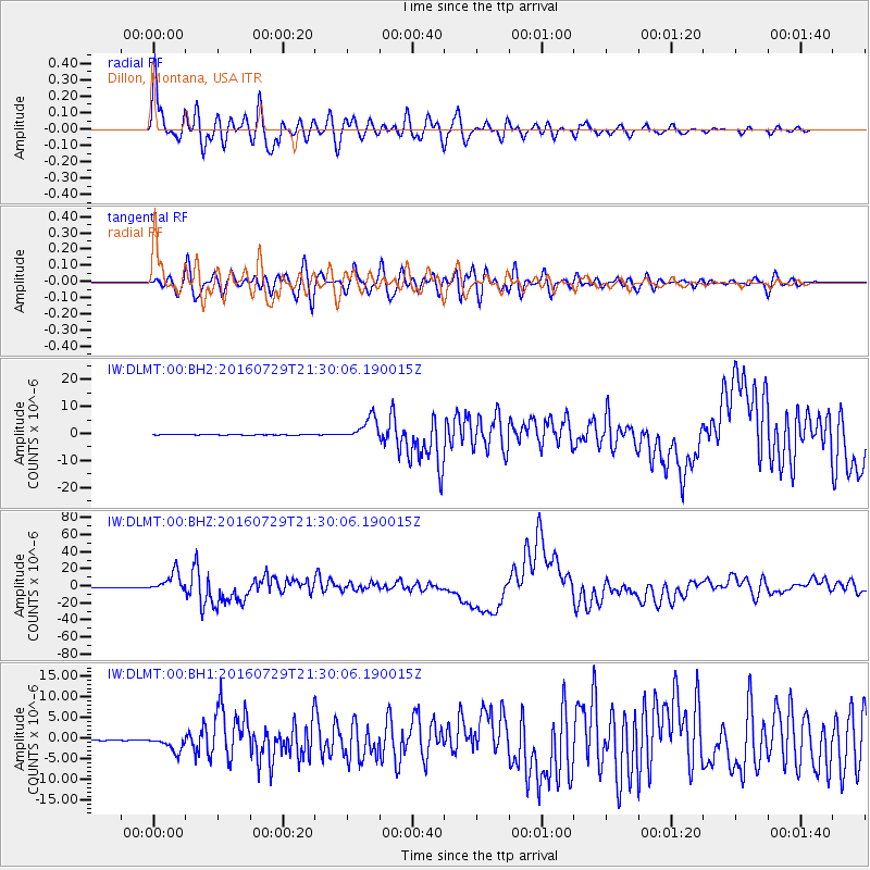
| Radial Match: |
95.22982 % |
| Radial Bump: |
400 |
| Transverse Match: |
80.22196 % |
| Transverse Bump: |
400 |
| SOD ConfigId: |
1634031 |
| Insert Time: |
2016-08-12 21:25:29.909 +0000 |
| GWidth: |
2.5 |
| Max Bumps: |
400 |
| Tol: |
0.001 |
|
Signal To Noise
| Channel | StoN | STA | LTA |
| IW:DLMT:00:BHZ:20160729T21:30:06.190015Z | 139.74596 | 1.1614288E-5 | 8.311001E-8 |
| IW:DLMT:00:BH1:20160729T21:30:06.190015Z | 30.153841 | 1.8652335E-6 | 6.185724E-8 |
| IW:DLMT:00:BH2:20160729T21:30:06.190015Z | 69.18837 | 4.167601E-6 | 6.023557E-8 |
| Arrivals |
| Ps | 5.0 SECOND |
| PpPs | 17 SECOND |
| PsPs/PpSs | 22 SECOND |


