You are here: Home > Network List > IW - Intermountain West Stations List
> Station PLID Pearl Lake, Idaho, USA > Earthquake Result Viewer
PLID Pearl Lake, Idaho, USA - Earthquake Result Viewer

| Earthquake location: |
Mariana Islands |
| Earthquake latitude/longitude: |
18.5/145.5 |
| Earthquake time(UTC): |
2016/07/29 (211) 21:18:25 GMT |
| Earthquake Depth: |
212 km |
| Earthquake Magnitude: |
7.7 MWW, 7.7 MWB, 7.7 MI |
| Earthquake Catalog/Contributor: |
NEIC PDE/NEIC COMCAT |
|
| Network: |
IW Intermountain West |
| Station: |
PLID Pearl Lake, Idaho, USA |
| Lat/Lon: |
45.09 N/116.00 W |
| Elevation: |
2164 m |
|
| Distance: |
82.9 deg |
| Az: |
44.919 deg |
| Baz: |
288.95 deg |
| Ray Param: |
0.046052355 |
| Estimated Moho Depth: |
57.0 km |
| Estimated Crust Vp/Vs: |
2.06 |
| Assumed Crust Vp: |
6.571 km/s |
| Estimated Crust Vs: |
3.194 km/s |
| Estimated Crust Poisson's Ratio: |
0.35 |
|
| Radial Match: |
95.590675 % |
| Radial Bump: |
400 |
| Transverse Match: |
88.44367 % |
| Transverse Bump: |
400 |
| SOD ConfigId: |
1634031 |
| Insert Time: |
2016-08-12 21:26:08.933 +0000 |
| GWidth: |
2.5 |
| Max Bumps: |
400 |
| Tol: |
0.001 |
|
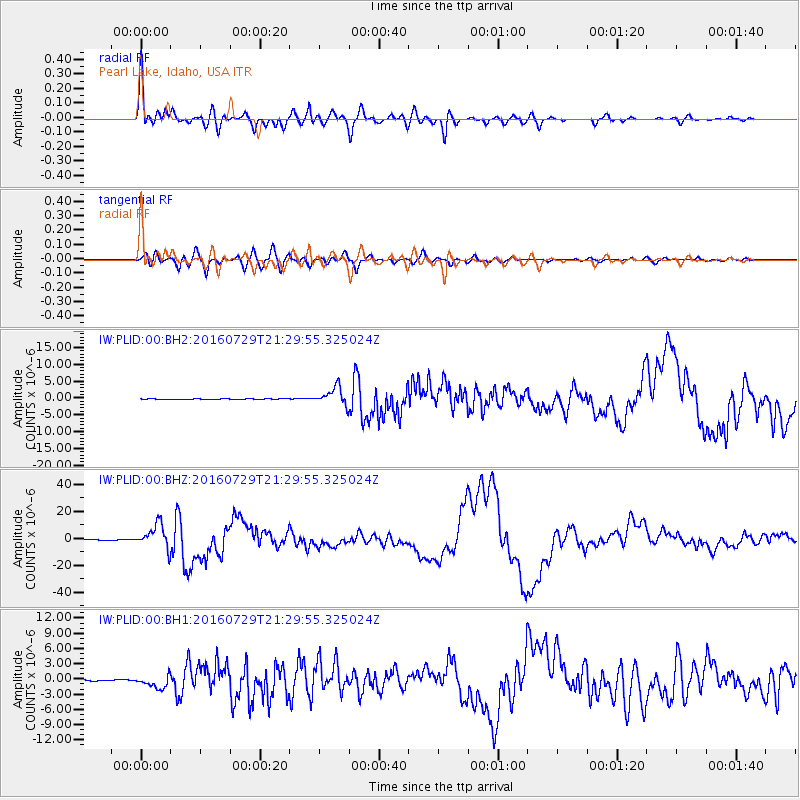
Signal To Noise
| Channel | StoN | STA | LTA |
| IW:PLID:00:BHZ:20160729T21:29:55.325024Z | 74.21253 | 9.043446E-6 | 1.2185875E-7 |
| IW:PLID:00:BH1:20160729T21:29:55.325024Z | 6.503842 | 1.1967572E-6 | 1.8400773E-7 |
| IW:PLID:00:BH2:20160729T21:29:55.325024Z | 60.074974 | 2.634702E-6 | 4.3856897E-8 |
| Arrivals |
| Ps | 9.4 SECOND |
| PpPs | 26 SECOND |
| PsPs/PpSs | 35 SECOND |


