You are here: Home > Network List > AT - Alaska Tsunami Warning Seismic System Stations List
> Station OHAK Old Harbor, Alaska > Earthquake Result Viewer
OHAK Old Harbor, Alaska - Earthquake Result Viewer
| Earthquake location: |
New Britain Region, P.N.G. |
| Earthquake latitude/longitude: |
-5.9/151.1 |
| Earthquake time(UTC): |
2018/10/10 (283) 21:13:16 GMT |
| Earthquake Depth: |
37 km |
| Earthquake Magnitude: |
5.9 Mww |
| Earthquake Catalog/Contributor: |
NEIC PDE/us |
|
| Network: |
AT Alaska Tsunami Warning Seismic System |
| Station: |
OHAK Old Harbor, Alaska |
| Lat/Lon: |
57.22 N/153.29 W |
| Elevation: |
78 m |
|
| Distance: |
77.3 deg |
| Az: |
27.383 deg |
| Baz: |
237.252 deg |
| Ray Param: |
0.05035121 |
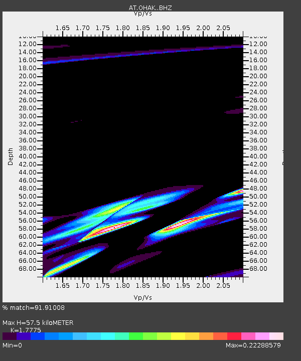
| Estimated Moho Depth: |
57.5 km |
| Estimated Crust Vp/Vs: |
1.78 |
| Assumed Crust Vp: |
6.134 km/s |
| Estimated Crust Vs: |
3.451 km/s |
| Estimated Crust Poisson's Ratio: |
0.27 |
|
| Radial Match: |
91.91008 % |
| Radial Bump: |
400 |
| Transverse Match: |
83.64309 % |
| Transverse Bump: |
362 |
| SOD ConfigId: |
13570011 |
| Insert Time: |
2019-05-01 11:27:17.846 +0000 |
| GWidth: |
2.5 |
| Max Bumps: |
400 |
| Tol: |
0.001 |
|

Signal To Noise
| Channel | StoN | STA | LTA |
| AT:OHAK: :BHZ:20181010T21:24:36.060005Z | 0.9769016 | 6.3604207E-6 | 6.51081E-6 |
| AT:OHAK: :BHN:20181010T21:24:36.060005Z | 1.3321866 | 4.9434484E-6 | 3.7107777E-6 |
| AT:OHAK: :BHE:20181010T21:24:36.060005Z | 1.9107822 | 4.2993956E-6 | 2.2500708E-6 |
| Arrivals |
| Ps | 7.5 SECOND |
| PpPs | 25 SECOND |
| PsPs/PpSs | 33 SECOND |


