You are here: Home > Network List > TS - TERRAscope (Southern California Seismic Network) Stations List
> Station BAR Barrett Dam, California, USA > Earthquake Result Viewer
BAR Barrett Dam, California, USA - Earthquake Result Viewer
| Earthquake location: |
Near East Coast Of Honshu, Japan |
| Earthquake latitude/longitude: |
40.2/142.2 |
| Earthquake time(UTC): |
1995/01/06 (006) 22:37:37 GMT |
| Earthquake Depth: |
57 km |
| Earthquake Magnitude: |
6.7 MB, 6.6 UNKNOWN, 7.0 MW |
| Earthquake Catalog/Contributor: |
WHDF/NEIC |
|
| Network: |
TS TERRAscope (Southern California Seismic Network) |
| Station: |
BAR Barrett Dam, California, USA |
| Lat/Lon: |
32.68 N/116.67 W |
| Elevation: |
548 m |
|
| Distance: |
77.2 deg |
| Az: |
58.07 deg |
| Baz: |
309.603 deg |
| Ray Param: |
0.05037241 |
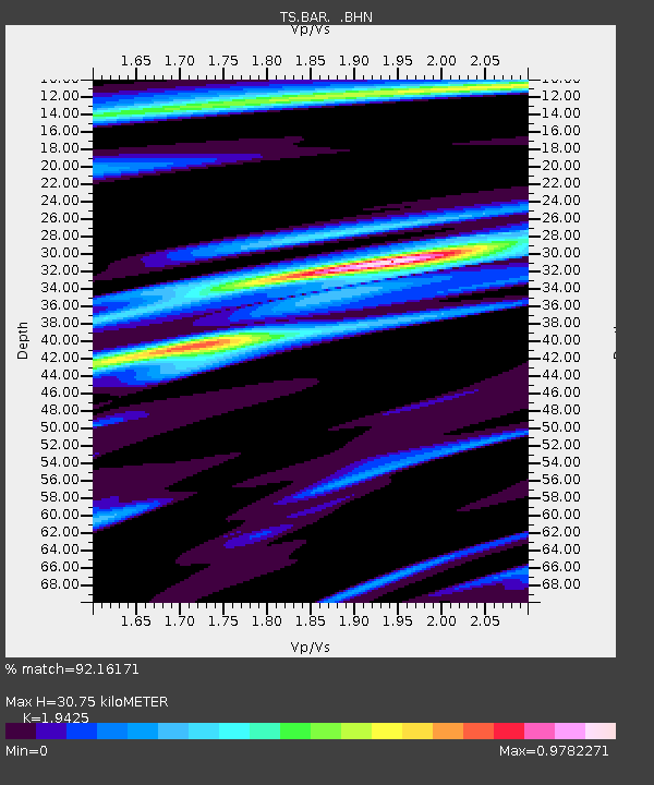
| Estimated Moho Depth: |
30.75 km |
| Estimated Crust Vp/Vs: |
1.94 |
| Assumed Crust Vp: |
6.264 km/s |
| Estimated Crust Vs: |
3.225 km/s |
| Estimated Crust Poisson's Ratio: |
0.32 |
|
| Radial Match: |
92.16171 % |
| Radial Bump: |
335 |
| Transverse Match: |
79.40511 % |
| Transverse Bump: |
400 |
| SOD ConfigId: |
6273 |
| Insert Time: |
2010-02-26 13:58:10.322 +0000 |
| GWidth: |
2.5 |
| Max Bumps: |
400 |
| Tol: |
0.001 |
|
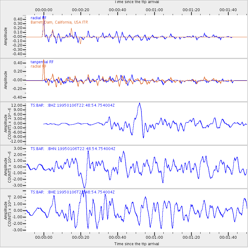
Signal To Noise
| Channel | StoN | STA | LTA |
| TS:BAR: :BHN:19950106T22:48:54.754004Z | 1.2171755 | 3.1566742E-7 | 2.593442E-7 |
| TS:BAR: :BHE:19950106T22:48:54.754004Z | 2.1059687 | 6.0783464E-7 | 2.886247E-7 |
| TS:BAR: :BHZ:19950106T22:48:54.754004Z | 2.159693 | 7.7905685E-7 | 3.6072575E-7 |
| Arrivals |
| Ps | 4.8 SECOND |
| PpPs | 14 SECOND |
| PsPs/PpSs | 19 SECOND |


