You are here: Home > Network List > ND - New CaleDonia Broadband Seismic Network Stations List
> Station KOUNC Koumac, New Caledonia > Earthquake Result Viewer
KOUNC Koumac, New Caledonia - Earthquake Result Viewer
| Earthquake location: |
Mariana Islands |
| Earthquake latitude/longitude: |
18.5/145.5 |
| Earthquake time(UTC): |
2016/07/29 (211) 21:18:25 GMT |
| Earthquake Depth: |
212 km |
| Earthquake Magnitude: |
7.7 MWW, 7.7 MWB, 7.7 MI |
| Earthquake Catalog/Contributor: |
NEIC PDE/NEIC COMCAT |
|
| Network: |
ND New CaleDonia Broadband Seismic Network |
| Station: |
KOUNC Koumac, New Caledonia |
| Lat/Lon: |
20.55 S/164.29 E |
| Elevation: |
88 m |
|
| Distance: |
43.0 deg |
| Az: |
153.756 deg |
| Baz: |
333.402 deg |
| Ray Param: |
0.07201335 |
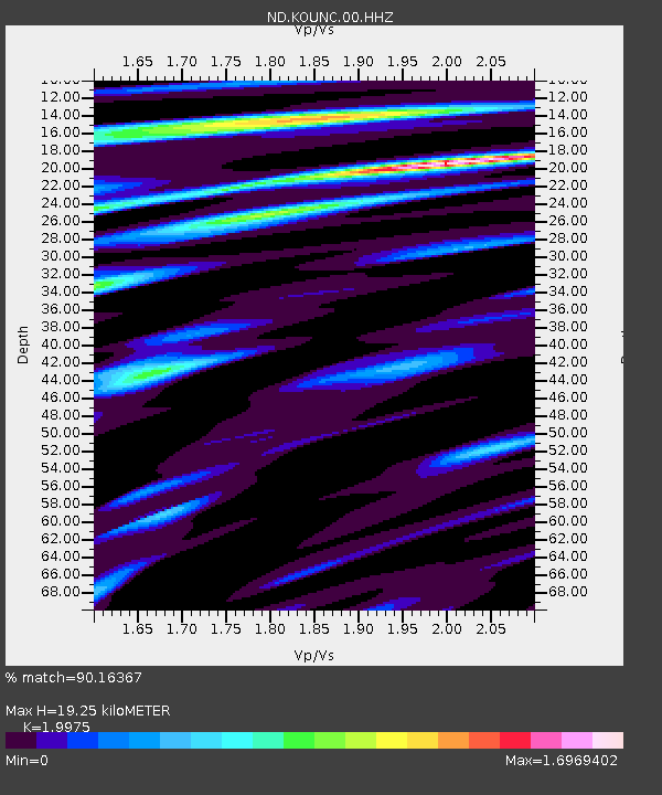
| Estimated Moho Depth: |
19.25 km |
| Estimated Crust Vp/Vs: |
2.00 |
| Assumed Crust Vp: |
5.14 km/s |
| Estimated Crust Vs: |
2.573 km/s |
| Estimated Crust Poisson's Ratio: |
0.33 |
|
| Radial Match: |
90.16367 % |
| Radial Bump: |
363 |
| Transverse Match: |
87.36493 % |
| Transverse Bump: |
400 |
| SOD ConfigId: |
1634031 |
| Insert Time: |
2016-08-12 21:26:44.026 +0000 |
| GWidth: |
2.5 |
| Max Bumps: |
400 |
| Tol: |
0.001 |
|
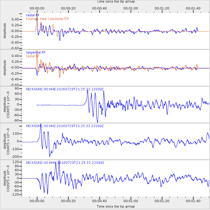
Signal To Noise
| Channel | StoN | STA | LTA |
| ND:KOUNC:00:HHZ:20160729T21:25:33.22099Z | 58.51814 | 9.7959324E-5 | 1.6739993E-6 |
| ND:KOUNC:00:HHN:20160729T21:25:33.22099Z | 44.751724 | 4.4685774E-5 | 9.985264E-7 |
| ND:KOUNC:00:HHE:20160729T21:25:33.22099Z | 60.096024 | 3.5921625E-5 | 5.9773714E-7 |
| Arrivals |
| Ps | 3.9 SECOND |
| PpPs | 11 SECOND |
| PsPs/PpSs | 15 SECOND |


