You are here: Home > Network List > TA - USArray Transportable Network (new EarthScope stations) Stations List
> Station F14K Arctic Creek, AK, USA > Earthquake Result Viewer
F14K Arctic Creek, AK, USA - Earthquake Result Viewer
| Earthquake location: |
New Britain Region, P.N.G. |
| Earthquake latitude/longitude: |
-5.9/151.1 |
| Earthquake time(UTC): |
2018/10/10 (283) 21:13:16 GMT |
| Earthquake Depth: |
37 km |
| Earthquake Magnitude: |
5.9 Mww |
| Earthquake Catalog/Contributor: |
NEIC PDE/us |
|
| Network: |
TA USArray Transportable Network (new EarthScope stations) |
| Station: |
F14K Arctic Creek, AK, USA |
| Lat/Lon: |
65.47 N/166.33 W |
| Elevation: |
266 m |
|
| Distance: |
77.7 deg |
| Az: |
16.786 deg |
| Baz: |
223.488 deg |
| Ray Param: |
0.050069008 |
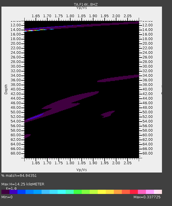
| Estimated Moho Depth: |
14.25 km |
| Estimated Crust Vp/Vs: |
1.60 |
| Assumed Crust Vp: |
6.307 km/s |
| Estimated Crust Vs: |
3.942 km/s |
| Estimated Crust Poisson's Ratio: |
0.18 |
|
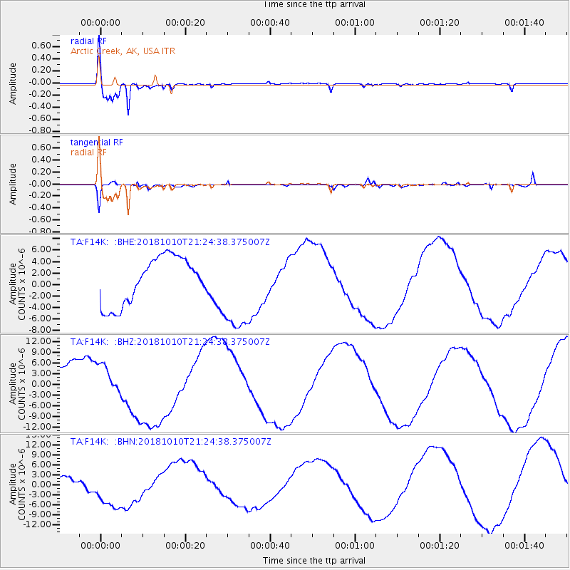
| Radial Match: |
94.94351 % |
| Radial Bump: |
273 |
| Transverse Match: |
65.25814 % |
| Transverse Bump: |
328 |
| SOD ConfigId: |
13570011 |
| Insert Time: |
2019-05-01 11:30:20.485 +0000 |
| GWidth: |
2.5 |
| Max Bumps: |
400 |
| Tol: |
0.001 |
|
Signal To Noise
| Channel | StoN | STA | LTA |
| TA:F14K: :BHZ:20181010T21:24:38.375007Z | 0.96425563 | 4.7424282E-6 | 4.918227E-6 |
| TA:F14K: :BHN:20181010T21:24:38.375007Z | 2.7481465 | 6.249589E-6 | 2.2741106E-6 |
| TA:F14K: :BHE:20181010T21:24:38.375007Z | 1.922893 | 7.687545E-6 | 3.9979054E-6 |
| Arrivals |
| Ps | 1.4 SECOND |
| PpPs | 5.7 SECOND |
| PsPs/PpSs | 7.1 SECOND |


