You are here: Home > Network List > NO - Norwegian Seismic Array Network Stations List
> Station SPA0 > Earthquake Result Viewer
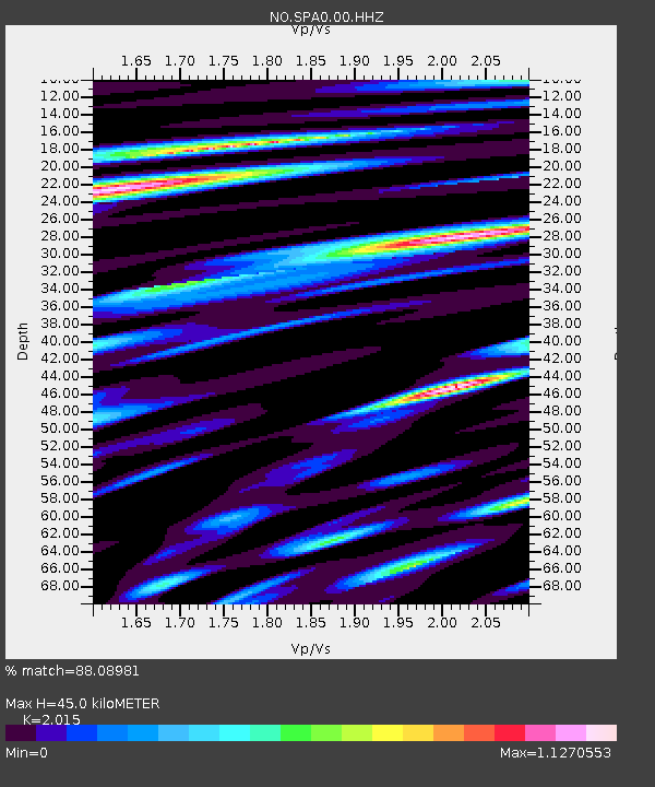
SPA0 - Earthquake Result Viewer
| Earthquake location: |
Mariana Islands |
| Earthquake latitude/longitude: |
18.5/145.5 |
| Earthquake time(UTC): |
2016/07/29 (211) 21:18:25 GMT |
| Earthquake Depth: |
212 km |
| Earthquake Magnitude: |
7.7 MWW, 7.7 MWB, 7.7 MI |
| Earthquake Catalog/Contributor: |
NEIC PDE/NEIC COMCAT |
|
| Network: |
NO Norwegian Seismic Array Network |
| Station: |
SPA0 |
| Lat/Lon: |
78.18 N/16.37 E |
| Elevation: |
323 m |
|
| Distance: |
79.3 deg |
| Az: |
350.636 deg |
| Baz: |
48.48 deg |
| Ray Param: |
0.048503414 |
| Estimated Moho Depth: |
45.0 km |
| Estimated Crust Vp/Vs: |
2.02 |
| Assumed Crust Vp: |
6.545 km/s |
| Estimated Crust Vs: |
3.248 km/s |
| Estimated Crust Poisson's Ratio: |
0.34 |
|
| Radial Match: |
88.08981 % |
| Radial Bump: |
400 |
| Transverse Match: |
92.433525 % |
| Transverse Bump: |
400 |
| SOD ConfigId: |
1634031 |
| Insert Time: |
2016-08-12 21:27:14.453 +0000 |
| GWidth: |
2.5 |
| Max Bumps: |
400 |
| Tol: |
0.001 |
|

Signal To Noise
| Channel | StoN | STA | LTA |
| NO:SPA0:00:HHZ:20160729T21:29:36.599988Z | 36.861324 | 5.569152E-6 | 1.510839E-7 |
| NO:SPA0:00:HHN:20160729T21:29:36.599988Z | 18.148838 | 1.9376532E-6 | 1.0676459E-7 |
| NO:SPA0:00:HHE:20160729T21:29:36.599988Z | 6.790899 | 8.3412885E-7 | 1.2283041E-7 |
| Arrivals |
| Ps | 7.2 SECOND |
| PpPs | 20 SECOND |
| PsPs/PpSs | 27 SECOND |


