You are here: Home > Network List > TA - USArray Transportable Network (new EarthScope stations) Stations List
> Station I30M Mount Dempster, Yukon, CAN > Earthquake Result Viewer
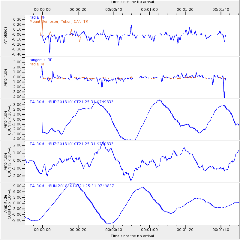
I30M Mount Dempster, Yukon, CAN - Earthquake Result Viewer
*The percent match for this event was below the threshold and hence no stack was calculated.
| Earthquake location: |
New Britain Region, P.N.G. |
| Earthquake latitude/longitude: |
-5.9/151.1 |
| Earthquake time(UTC): |
2018/10/10 (283) 21:13:16 GMT |
| Earthquake Depth: |
37 km |
| Earthquake Magnitude: |
5.9 Mww |
| Earthquake Catalog/Contributor: |
NEIC PDE/us |
|
| Network: |
TA USArray Transportable Network (new EarthScope stations) |
| Station: |
I30M Mount Dempster, Yukon, CAN |
| Lat/Lon: |
65.22 N/136.38 W |
| Elevation: |
1399 m |
|
| Distance: |
88.1 deg |
| Az: |
23.71 deg |
| Baz: |
251.645 deg |
| Ray Param: |
$rayparam |
*The percent match for this event was below the threshold and hence was not used in the summary stack. |
|
| Radial Match: |
59.519646 % |
| Radial Bump: |
400 |
| Transverse Match: |
62.90086 % |
| Transverse Bump: |
371 |
| SOD ConfigId: |
13570011 |
| Insert Time: |
2019-05-01 11:30:32.813 +0000 |
| GWidth: |
2.5 |
| Max Bumps: |
400 |
| Tol: |
0.001 |
|
Signal To Noise
| Channel | StoN | STA | LTA |
| TA:I30M: :BHZ:20181010T21:25:31.974983Z | 1.4134398 | 1.547343E-6 | 1.0947357E-6 |
| TA:I30M: :BHN:20181010T21:25:31.974983Z | 0.9408594 | 6.2478684E-6 | 6.640598E-6 |
| TA:I30M: :BHE:20181010T21:25:31.974983Z | 2.010153 | 3.8436824E-6 | 1.9121342E-6 |
| Arrivals |
| Ps | |
| PpPs | |
| PsPs/PpSs | |


