You are here: Home > Network List > TA - USArray Transportable Network (new EarthScope stations) Stations List
> Station J18K Innoko River, AK, USA > Earthquake Result Viewer
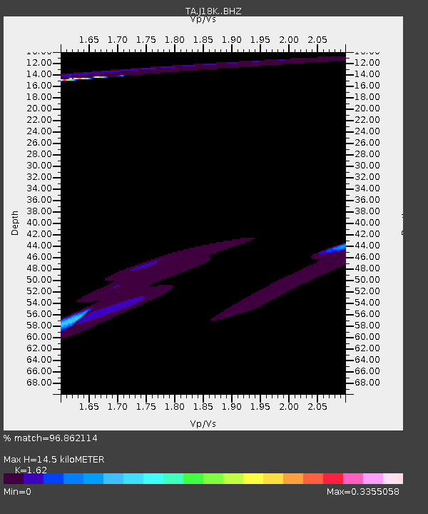
J18K Innoko River, AK, USA - Earthquake Result Viewer
| Earthquake location: |
New Britain Region, P.N.G. |
| Earthquake latitude/longitude: |
-5.9/151.1 |
| Earthquake time(UTC): |
2018/10/10 (283) 21:13:16 GMT |
| Earthquake Depth: |
37 km |
| Earthquake Magnitude: |
5.9 Mww |
| Earthquake Catalog/Contributor: |
NEIC PDE/us |
|
| Network: |
TA USArray Transportable Network (new EarthScope stations) |
| Station: |
J18K Innoko River, AK, USA |
| Lat/Lon: |
63.47 N/156.72 W |
| Elevation: |
506 m |
|
| Distance: |
79.5 deg |
| Az: |
21.143 deg |
| Baz: |
233.018 deg |
| Ray Param: |
0.04886665 |
| Estimated Moho Depth: |
14.5 km |
| Estimated Crust Vp/Vs: |
1.62 |
| Assumed Crust Vp: |
6.182 km/s |
| Estimated Crust Vs: |
3.816 km/s |
| Estimated Crust Poisson's Ratio: |
0.19 |
|
| Radial Match: |
96.862114 % |
| Radial Bump: |
301 |
| Transverse Match: |
80.85677 % |
| Transverse Bump: |
347 |
| SOD ConfigId: |
13570011 |
| Insert Time: |
2019-05-01 11:30:33.388 +0000 |
| GWidth: |
2.5 |
| Max Bumps: |
400 |
| Tol: |
0.001 |
|

Signal To Noise
| Channel | StoN | STA | LTA |
| TA:J18K: :BHZ:20181010T21:24:48.07502Z | 1.4785051 | 2.6726013E-6 | 1.8076374E-6 |
| TA:J18K: :BHN:20181010T21:24:48.07502Z | 2.10159 | 3.337444E-6 | 1.5880568E-6 |
| TA:J18K: :BHE:20181010T21:24:48.07502Z | 5.1882577 | 4.8639686E-6 | 9.3749566E-7 |
| Arrivals |
| Ps | 1.5 SECOND |
| PpPs | 6.0 SECOND |
| PsPs/PpSs | 7.5 SECOND |


