You are here: Home > Network List > TA - USArray Transportable Network (new EarthScope stations) Stations List
> Station Q19K Cape Douglas, AK, USA > Earthquake Result Viewer
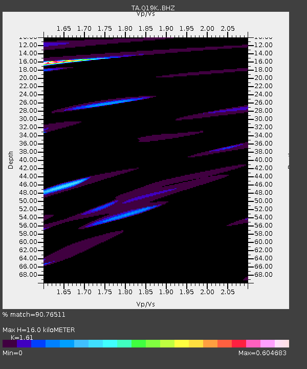
Q19K Cape Douglas, AK, USA - Earthquake Result Viewer
| Earthquake location: |
New Britain Region, P.N.G. |
| Earthquake latitude/longitude: |
-5.9/151.1 |
| Earthquake time(UTC): |
2018/10/10 (283) 21:13:16 GMT |
| Earthquake Depth: |
37 km |
| Earthquake Magnitude: |
5.9 Mww |
| Earthquake Catalog/Contributor: |
NEIC PDE/us |
|
| Network: |
TA USArray Transportable Network (new EarthScope stations) |
| Station: |
Q19K Cape Douglas, AK, USA |
| Lat/Lon: |
58.93 N/153.64 W |
| Elevation: |
631 m |
|
| Distance: |
78.1 deg |
| Az: |
25.809 deg |
| Baz: |
236.614 deg |
| Ray Param: |
0.04982427 |
| Estimated Moho Depth: |
16.0 km |
| Estimated Crust Vp/Vs: |
1.61 |
| Assumed Crust Vp: |
5.989 km/s |
| Estimated Crust Vs: |
3.72 km/s |
| Estimated Crust Poisson's Ratio: |
0.19 |
|
| Radial Match: |
90.76511 % |
| Radial Bump: |
400 |
| Transverse Match: |
69.05091 % |
| Transverse Bump: |
400 |
| SOD ConfigId: |
13570011 |
| Insert Time: |
2019-05-01 11:30:53.894 +0000 |
| GWidth: |
2.5 |
| Max Bumps: |
400 |
| Tol: |
0.001 |
|

Signal To Noise
| Channel | StoN | STA | LTA |
| TA:Q19K: :BHZ:20181010T21:24:40.375007Z | 2.9002497 | 1.0573213E-5 | 3.645622E-6 |
| TA:Q19K: :BHN:20181010T21:24:40.375007Z | 1.2123324 | 3.8988323E-6 | 3.2159767E-6 |
| TA:Q19K: :BHE:20181010T21:24:40.375007Z | 0.7875227 | 3.1432226E-6 | 3.991279E-6 |
| Arrivals |
| Ps | 1.7 SECOND |
| PpPs | 6.8 SECOND |
| PsPs/PpSs | 8.5 SECOND |


