You are here: Home > Network List > US - United States National Seismic Network Stations List
> Station AMTX Amarillo, Texas, USA > Earthquake Result Viewer
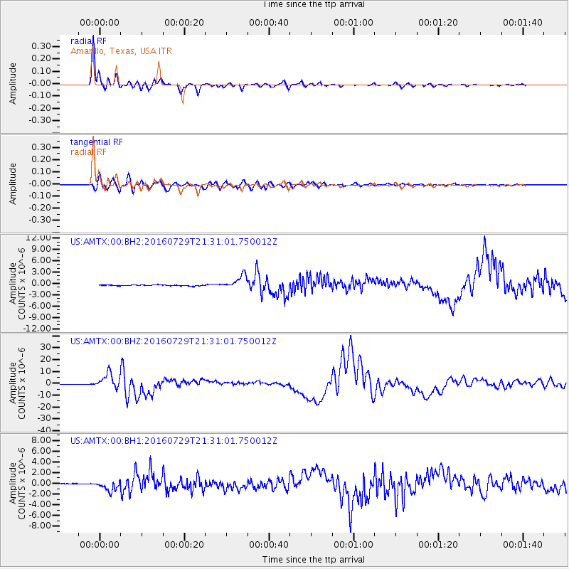
AMTX Amarillo, Texas, USA - Earthquake Result Viewer
*The percent match for this event was below the threshold and hence no stack was calculated.
| Earthquake location: |
Mariana Islands |
| Earthquake latitude/longitude: |
18.5/145.5 |
| Earthquake time(UTC): |
2016/07/29 (211) 21:18:25 GMT |
| Earthquake Depth: |
212 km |
| Earthquake Magnitude: |
7.7 MWW, 7.7 MWB, 7.7 MI |
| Earthquake Catalog/Contributor: |
NEIC PDE/NEIC COMCAT |
|
| Network: |
US United States National Seismic Network |
| Station: |
AMTX Amarillo, Texas, USA |
| Lat/Lon: |
34.53 N/101.41 W |
| Elevation: |
1010 m |
|
| Distance: |
97.4 deg |
| Az: |
49.996 deg |
| Baz: |
298.313 deg |
| Ray Param: |
$rayparam |
*The percent match for this event was below the threshold and hence was not used in the summary stack. |
|
| Radial Match: |
98.39879 % |
| Radial Bump: |
285 |
| Transverse Match: |
91.60572 % |
| Transverse Bump: |
400 |
| SOD ConfigId: |
1634031 |
| Insert Time: |
2016-08-12 21:27:59.090 +0000 |
| GWidth: |
2.5 |
| Max Bumps: |
400 |
| Tol: |
0.001 |
|
Signal To Noise
| Channel | StoN | STA | LTA |
| US:AMTX:00:BHZ:20160729T21:31:01.750012Z | 84.13393 | 6.5843583E-6 | 7.826045E-8 |
| US:AMTX:00:BH1:20160729T21:31:01.750012Z | 11.410005 | 9.658335E-7 | 8.4647944E-8 |
| US:AMTX:00:BH2:20160729T21:31:01.750012Z | 14.592519 | 1.8985237E-6 | 1.3010253E-7 |
| Arrivals |
| Ps | |
| PpPs | |
| PsPs/PpSs | |


