You are here: Home > Network List > TS - TERRAscope (Southern California Seismic Network) Stations List
> Station BAR Barrett Dam, California, USA > Earthquake Result Viewer
BAR Barrett Dam, California, USA - Earthquake Result Viewer
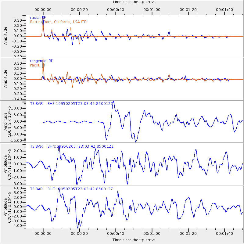
| Earthquake location: |
Off E. Coast Of N. Island, N.Z. |
| Earthquake latitude/longitude: |
-37.7/178.8 |
| Earthquake time(UTC): |
1995/02/05 (036) 22:51:10 GMT |
| Earthquake Depth: |
59 km |
| Earthquake Magnitude: |
6.4 MB, 7.1 UNKNOWN, 7.1 MW |
| Earthquake Catalog/Contributor: |
WHDF/NEIC |
|
| Network: |
TS TERRAscope (Southern California Seismic Network) |
| Station: |
BAR Barrett Dam, California, USA |
| Lat/Lon: |
32.68 N/116.67 W |
| Elevation: |
548 m |
|
| Distance: |
92.3 deg |
| Az: |
49.656 deg |
| Baz: |
225.785 deg |
| Ray Param: |
0.041459035 |
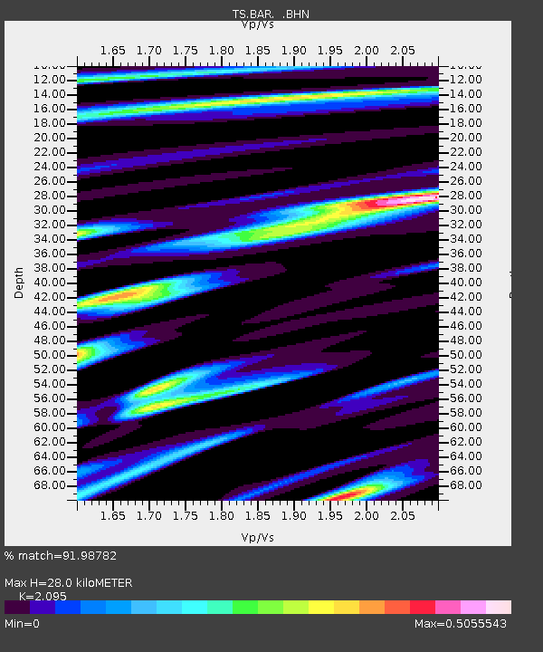
| Estimated Moho Depth: |
28.0 km |
| Estimated Crust Vp/Vs: |
2.10 |
| Assumed Crust Vp: |
6.264 km/s |
| Estimated Crust Vs: |
2.99 km/s |
| Estimated Crust Poisson's Ratio: |
0.35 |
|
| Radial Match: |
91.98782 % |
| Radial Bump: |
372 |
| Transverse Match: |
81.790344 % |
| Transverse Bump: |
400 |
| SOD ConfigId: |
6273 |
| Insert Time: |
2010-02-26 13:58:12.244 +0000 |
| GWidth: |
2.5 |
| Max Bumps: |
400 |
| Tol: |
0.001 |
|
Signal To Noise
| Channel | StoN | STA | LTA |
| TS:BAR: :BHN:19950205T23:03:42.850012Z | 2.3715243 | 7.788678E-7 | 3.2842493E-7 |
| TS:BAR: :BHE:19950205T23:03:42.850012Z | 2.4663782 | 9.4982494E-7 | 3.851092E-7 |
| TS:BAR: :BHZ:19950205T23:03:42.850012Z | 9.54967 | 4.1653784E-6 | 4.3618033E-7 |
| Arrivals |
| Ps | 5.0 SECOND |
| PpPs | 14 SECOND |
| PsPs/PpSs | 19 SECOND |


