You are here: Home > Network List > US - United States National Seismic Network Stations List
> Station DGMT Dagmar, Montana, USA > Earthquake Result Viewer
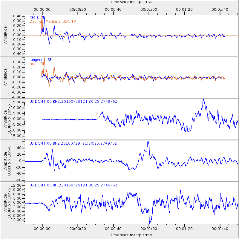
DGMT Dagmar, Montana, USA - Earthquake Result Viewer
*The percent match for this event was below the threshold and hence no stack was calculated.
| Earthquake location: |
Mariana Islands |
| Earthquake latitude/longitude: |
18.5/145.5 |
| Earthquake time(UTC): |
2016/07/29 (211) 21:18:25 GMT |
| Earthquake Depth: |
212 km |
| Earthquake Magnitude: |
7.7 MWW, 7.7 MWB, 7.7 MI |
| Earthquake Catalog/Contributor: |
NEIC PDE/NEIC COMCAT |
|
| Network: |
US United States National Seismic Network |
| Station: |
DGMT Dagmar, Montana, USA |
| Lat/Lon: |
48.47 N/104.20 W |
| Elevation: |
0.0 m |
|
| Distance: |
89.0 deg |
| Az: |
38.635 deg |
| Baz: |
297.101 deg |
| Ray Param: |
$rayparam |
*The percent match for this event was below the threshold and hence was not used in the summary stack. |
|
| Radial Match: |
96.861626 % |
| Radial Bump: |
400 |
| Transverse Match: |
83.26256 % |
| Transverse Bump: |
400 |
| SOD ConfigId: |
1634031 |
| Insert Time: |
2016-08-12 21:28:31.358 +0000 |
| GWidth: |
2.5 |
| Max Bumps: |
400 |
| Tol: |
0.001 |
|
Signal To Noise
| Channel | StoN | STA | LTA |
| US:DGMT:00:BHZ:20160729T21:30:25.274976Z | 86.375374 | 1.1527004E-5 | 1.3345243E-7 |
| US:DGMT:00:BH1:20160729T21:30:25.274976Z | 16.11408 | 2.5167217E-6 | 1.5618153E-7 |
| US:DGMT:00:BH2:20160729T21:30:25.274976Z | 22.883947 | 3.2330424E-6 | 1.4127993E-7 |
| Arrivals |
| Ps | |
| PpPs | |
| PsPs/PpSs | |


