You are here: Home > Network List > TA - USArray Transportable Network (new EarthScope stations) Stations List
> Station D25K Kavik River, AK, USA > Earthquake Result Viewer
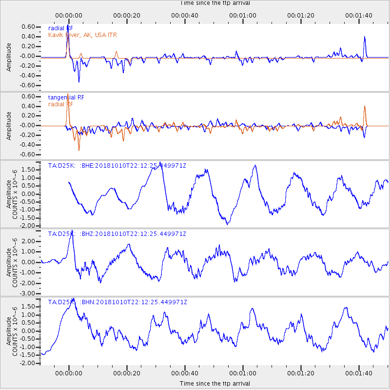
D25K Kavik River, AK, USA - Earthquake Result Viewer
*The percent match for this event was below the threshold and hence no stack was calculated.
| Earthquake location: |
New Britain Region, P.N.G. |
| Earthquake latitude/longitude: |
-5.0/151.7 |
| Earthquake time(UTC): |
2018/10/10 (283) 22:00:34 GMT |
| Earthquake Depth: |
124 km |
| Earthquake Magnitude: |
6.3 Mww |
| Earthquake Catalog/Contributor: |
NEIC PDE/us |
|
| Network: |
TA USArray Transportable Network (new EarthScope stations) |
| Station: |
D25K Kavik River, AK, USA |
| Lat/Lon: |
69.32 N/146.38 W |
| Elevation: |
770 m |
|
| Distance: |
85.1 deg |
| Az: |
18.339 deg |
| Baz: |
241.948 deg |
| Ray Param: |
$rayparam |
*The percent match for this event was below the threshold and hence was not used in the summary stack. |
|
| Radial Match: |
68.70991 % |
| Radial Bump: |
285 |
| Transverse Match: |
75.77399 % |
| Transverse Bump: |
400 |
| SOD ConfigId: |
13570011 |
| Insert Time: |
2019-05-01 11:37:54.326 +0000 |
| GWidth: |
2.5 |
| Max Bumps: |
400 |
| Tol: |
0.001 |
|
Signal To Noise
| Channel | StoN | STA | LTA |
| TA:D25K: :BHZ:20181010T22:12:25.449971Z | 3.2683823 | 1.5382459E-6 | 4.706444E-7 |
| TA:D25K: :BHN:20181010T22:12:25.449971Z | 3.5742044 | 1.7906694E-6 | 5.0099806E-7 |
| TA:D25K: :BHE:20181010T22:12:25.449971Z | 3.259873 | 1.6239454E-6 | 4.981622E-7 |
| Arrivals |
| Ps | |
| PpPs | |
| PsPs/PpSs | |


