You are here: Home > Network List > TA - USArray Transportable Network (new EarthScope stations) Stations List
> Station I14A Mackay, ID, USA > Earthquake Result Viewer
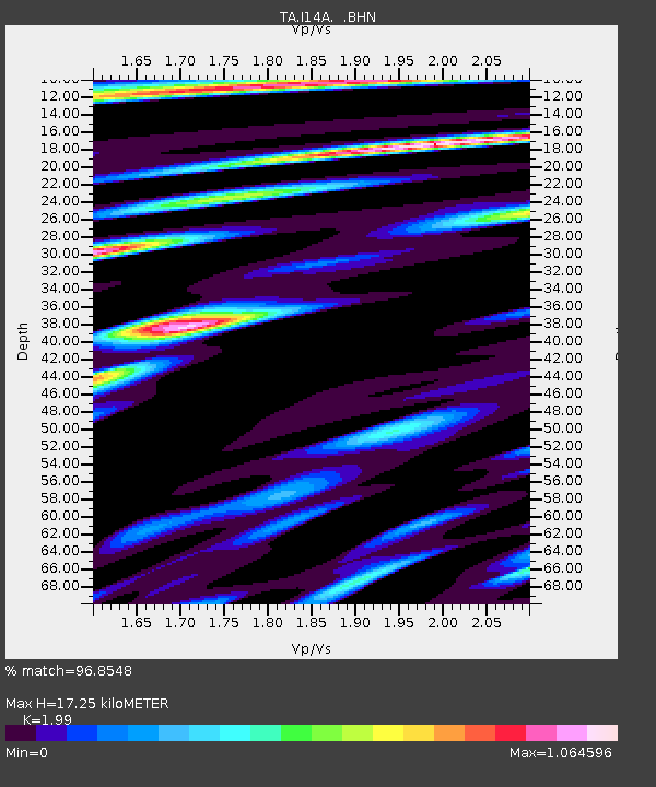
I14A Mackay, ID, USA - Earthquake Result Viewer
| Earthquake location: |
Eastern Honshu, Japan |
| Earthquake latitude/longitude: |
39.8/141.5 |
| Earthquake time(UTC): |
2008/07/23 (205) 15:26:19 GMT |
| Earthquake Depth: |
108 km |
| Earthquake Magnitude: |
6.6 MB, 6.8 MW, 6.8 MW |
| Earthquake Catalog/Contributor: |
WHDF/NEIC |
|
| Network: |
TA USArray Transportable Network (new EarthScope stations) |
| Station: |
I14A Mackay, ID, USA |
| Lat/Lon: |
43.93 N/113.45 W |
| Elevation: |
1897 m |
|
| Distance: |
72.8 deg |
| Az: |
46.916 deg |
| Baz: |
308.857 deg |
| Ray Param: |
0.053171236 |
| Estimated Moho Depth: |
17.25 km |
| Estimated Crust Vp/Vs: |
1.99 |
| Assumed Crust Vp: |
6.279 km/s |
| Estimated Crust Vs: |
3.155 km/s |
| Estimated Crust Poisson's Ratio: |
0.33 |
|
| Radial Match: |
96.8548 % |
| Radial Bump: |
400 |
| Transverse Match: |
95.15424 % |
| Transverse Bump: |
400 |
| SOD ConfigId: |
2504 |
| Insert Time: |
2010-03-06 16:41:54.151 +0000 |
| GWidth: |
2.5 |
| Max Bumps: |
400 |
| Tol: |
0.001 |
|

Signal To Noise
| Channel | StoN | STA | LTA |
| TA:I14A: :BHN:20080723T15:37:05.749011Z | 28.248074 | 3.474411E-6 | 1.2299638E-7 |
| TA:I14A: :BHE:20080723T15:37:05.749011Z | 10.165397 | 9.3600556E-7 | 9.207762E-8 |
| TA:I14A: :BHZ:20080723T15:37:05.749011Z | 20.017881 | 1.3082546E-6 | 6.53543E-8 |
| Arrivals |
| Ps | 2.8 SECOND |
| PpPs | 8.0 SECOND |
| PsPs/PpSs | 11 SECOND |


