You are here: Home > Network List > TA - USArray Transportable Network (new EarthScope stations) Stations List
> Station J26L Joseph Creek, AK, USA > Earthquake Result Viewer
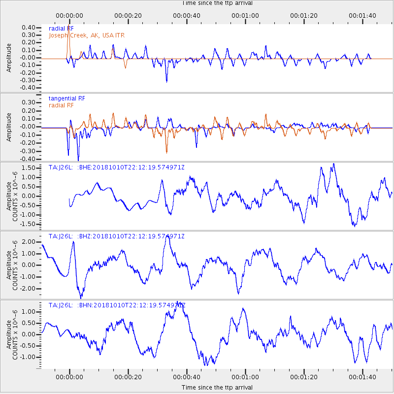
J26L Joseph Creek, AK, USA - Earthquake Result Viewer
*The percent match for this event was below the threshold and hence no stack was calculated.
| Earthquake location: |
New Britain Region, P.N.G. |
| Earthquake latitude/longitude: |
-5.0/151.7 |
| Earthquake time(UTC): |
2018/10/10 (283) 22:00:34 GMT |
| Earthquake Depth: |
124 km |
| Earthquake Magnitude: |
6.3 Mww |
| Earthquake Catalog/Contributor: |
NEIC PDE/us |
|
| Network: |
TA USArray Transportable Network (new EarthScope stations) |
| Station: |
J26L Joseph Creek, AK, USA |
| Lat/Lon: |
64.50 N/143.56 W |
| Elevation: |
1144 m |
|
| Distance: |
83.9 deg |
| Az: |
23.188 deg |
| Baz: |
245.002 deg |
| Ray Param: |
$rayparam |
*The percent match for this event was below the threshold and hence was not used in the summary stack. |
|
| Radial Match: |
66.12516 % |
| Radial Bump: |
400 |
| Transverse Match: |
75.24448 % |
| Transverse Bump: |
361 |
| SOD ConfigId: |
13570011 |
| Insert Time: |
2019-05-01 11:38:38.760 +0000 |
| GWidth: |
2.5 |
| Max Bumps: |
400 |
| Tol: |
0.001 |
|
Signal To Noise
| Channel | StoN | STA | LTA |
| TA:J26L: :BHZ:20181010T22:12:19.574971Z | 1.7446568 | 1.7475907E-6 | 1.0016817E-6 |
| TA:J26L: :BHN:20181010T22:12:19.574971Z | 0.15483148 | 1.1761002E-7 | 7.596002E-7 |
| TA:J26L: :BHE:20181010T22:12:19.574971Z | 1.3878038 | 5.7865543E-7 | 4.1695765E-7 |
| Arrivals |
| Ps | |
| PpPs | |
| PsPs/PpSs | |


