You are here: Home > Network List > TA - USArray Transportable Network (new EarthScope stations) Stations List
> Station M16K Timber Creek, AK, USA > Earthquake Result Viewer
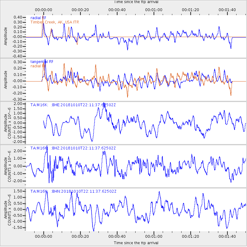
M16K Timber Creek, AK, USA - Earthquake Result Viewer
*The percent match for this event was below the threshold and hence no stack was calculated.
| Earthquake location: |
New Britain Region, P.N.G. |
| Earthquake latitude/longitude: |
-5.0/151.7 |
| Earthquake time(UTC): |
2018/10/10 (283) 22:00:34 GMT |
| Earthquake Depth: |
124 km |
| Earthquake Magnitude: |
6.3 Mww |
| Earthquake Catalog/Contributor: |
NEIC PDE/us |
|
| Network: |
TA USArray Transportable Network (new EarthScope stations) |
| Station: |
M16K Timber Creek, AK, USA |
| Lat/Lon: |
61.02 N/158.96 W |
| Elevation: |
394 m |
|
| Distance: |
76.1 deg |
| Az: |
22.38 deg |
| Baz: |
231.168 deg |
| Ray Param: |
$rayparam |
*The percent match for this event was below the threshold and hence was not used in the summary stack. |
|
| Radial Match: |
51.219418 % |
| Radial Bump: |
400 |
| Transverse Match: |
59.159306 % |
| Transverse Bump: |
400 |
| SOD ConfigId: |
13570011 |
| Insert Time: |
2019-05-01 11:38:54.588 +0000 |
| GWidth: |
2.5 |
| Max Bumps: |
400 |
| Tol: |
0.001 |
|
Signal To Noise
| Channel | StoN | STA | LTA |
| TA:M16K: :BHZ:20181010T22:11:37.62502Z | 2.6816194 | 1.3611312E-6 | 5.075781E-7 |
| TA:M16K: :BHN:20181010T22:11:37.62502Z | 1.3770099 | 7.4876243E-7 | 5.437597E-7 |
| TA:M16K: :BHE:20181010T22:11:37.62502Z | 2.3467696 | 1.5630266E-6 | 6.6603326E-7 |
| Arrivals |
| Ps | |
| PpPs | |
| PsPs/PpSs | |


