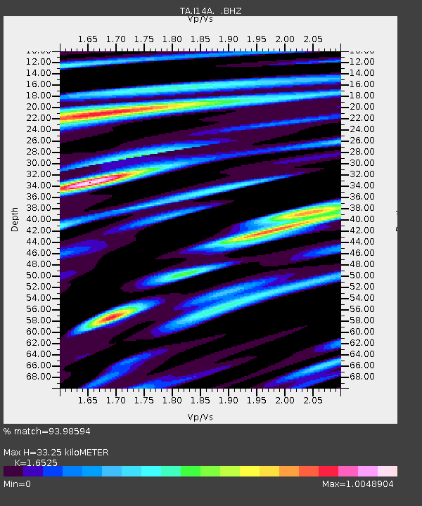
I14A Mackay, ID, USA - Earthquake Result Viewer

Earthquake location: Near Coast Of Chiapas, Mexico
Earthquake latitude/longitude: 14.4/-92.4
Earthquake time(UTC): 2008/10/16 (290) 19:41:25 GMT
Earthquake Depth: 24 km
Earthquake Magnitude: 6.1 MB, 6.6 MS, 6.7 MW, 6.6 MW
Earthquake Catalog/Contributor: WHDF/NEIC
Network: TA USArray Transportable Network (new EarthScope stations)
Station: I14A Mackay, ID, USA
Lat/Lon: 43.93 N/113.45 W
Elevation: 1897 m
Distance: 34.5 deg
Az: 332.667 deg
Baz: 141.997 deg
Ray Param: 0.07768317
Estimated Moho Depth: 33.25 km
Estimated Crust Vp/Vs: 1.65
Assumed Crust Vp: 6.279 km/s
Estimated Crust Vs: 3.799 km/s
Estimated Crust Poisson's Ratio: 0.21
Radial Match: 93.98594 %
Radial Bump: 400
Transverse Match: 79.99773 %
Transverse Bump: 400
SOD ConfigId: 2556
Insert Time: 2010-03-06 16:42:06.065 +0000
GWidth: 2.5
Max Bumps: 400
Tol: 0.001

Signal To Noise

ChannelStoNSTALTA
TA:I14A: :BHZ:20081016T19:47:41.075011Z13.7808092.8613504E-62.0763297E-7
TA:I14A: :BHN:20081016T19:47:41.075011Z7.9936861.5855712E-61.9835295E-7
TA:I14A: :BHE:20081016T19:47:41.075011Z7.62649061.1542659E-61.5134955E-7
Arrivals
Ps3.7 SECOND
PpPs13 SECOND
PsPs/PpSs17 SECOND