You are here: Home > Network List > TA - USArray Transportable Network (new EarthScope stations) Stations List
> Station I14A Mackay, ID, USA > Earthquake Result Viewer
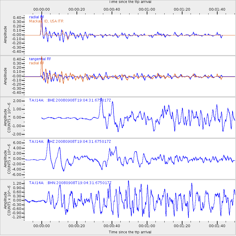
I14A Mackay, ID, USA - Earthquake Result Viewer

| Earthquake location: |
Vanuatu Islands |
| Earthquake latitude/longitude: |
-13.5/167.0 |
| Earthquake time(UTC): |
2008/09/08 (252) 18:52:06 GMT |
| Earthquake Depth: |
110 km |
| Earthquake Magnitude: |
6.4 MB, 6.9 MW, 6.9 MW |
| Earthquake Catalog/Contributor: |
WHDF/NEIC |
|
| Network: |
TA USArray Transportable Network (new EarthScope stations) |
| Station: |
I14A Mackay, ID, USA |
| Lat/Lon: |
43.93 N/113.45 W |
| Elevation: |
1897 m |
|
| Distance: |
91.9 deg |
| Az: |
45.317 deg |
| Baz: |
253.179 deg |
| Ray Param: |
0.041492354 |
| Estimated Moho Depth: |
17.75 km |
| Estimated Crust Vp/Vs: |
1.89 |
| Assumed Crust Vp: |
6.279 km/s |
| Estimated Crust Vs: |
3.318 km/s |
| Estimated Crust Poisson's Ratio: |
0.31 |
|
| Radial Match: |
95.41596 % |
| Radial Bump: |
400 |
| Transverse Match: |
86.45035 % |
| Transverse Bump: |
400 |
| SOD ConfigId: |
2560 |
| Insert Time: |
2010-03-06 16:42:13.359 +0000 |
| GWidth: |
2.5 |
| Max Bumps: |
400 |
| Tol: |
0.001 |
|
Signal To Noise
| Channel | StoN | STA | LTA |
| TA:I14A: :BHZ:20080908T19:04:31.675017Z | 29.338655 | 3.3703225E-6 | 1.14876514E-7 |
| TA:I14A: :BHN:20080908T19:04:31.675017Z | 3.8508754 | 2.5076736E-7 | 6.511957E-8 |
| TA:I14A: :BHE:20080908T19:04:31.675017Z | 17.935879 | 1.0548889E-6 | 5.8814454E-8 |
| Arrivals |
| Ps | 2.6 SECOND |
| PpPs | 8.0 SECOND |
| PsPs/PpSs | 11 SECOND |


