You are here: Home > Network List > TJ - Tajikistan National Seismic Network Stations List
> Station CHRDR Chorukh Dayron, Tajikistan > Earthquake Result Viewer
CHRDR Chorukh Dayron, Tajikistan - Earthquake Result Viewer
| Earthquake location: |
New Britain Region, P.N.G. |
| Earthquake latitude/longitude: |
-5.0/151.7 |
| Earthquake time(UTC): |
2018/10/10 (283) 22:00:34 GMT |
| Earthquake Depth: |
124 km |
| Earthquake Magnitude: |
6.3 Mww |
| Earthquake Catalog/Contributor: |
NEIC PDE/us |
|
| Network: |
TJ Tajikistan National Seismic Network |
| Station: |
CHRDR Chorukh Dayron, Tajikistan |
| Lat/Lon: |
40.39 N/69.67 E |
| Elevation: |
580 m |
|
| Distance: |
87.1 deg |
| Az: |
310.767 deg |
| Baz: |
98.928 deg |
| Ray Param: |
0.043296047 |
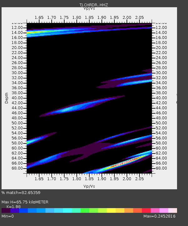
| Estimated Moho Depth: |
65.75 km |
| Estimated Crust Vp/Vs: |
1.98 |
| Assumed Crust Vp: |
6.316 km/s |
| Estimated Crust Vs: |
3.19 km/s |
| Estimated Crust Poisson's Ratio: |
0.33 |
|
| Radial Match: |
82.65359 % |
| Radial Bump: |
393 |
| Transverse Match: |
79.00275 % |
| Transverse Bump: |
400 |
| SOD ConfigId: |
13570011 |
| Insert Time: |
2019-05-01 11:39:25.014 +0000 |
| GWidth: |
2.5 |
| Max Bumps: |
400 |
| Tol: |
0.001 |
|

Signal To Noise
| Channel | StoN | STA | LTA |
| TJ:CHRDR: :HHZ:20181010T22:12:35.71999Z | 4.834707 | 4.4309254E-6 | 9.1648275E-7 |
| TJ:CHRDR: :HHN:20181010T22:12:35.71999Z | 0.34117448 | 3.4592824E-7 | 1.0139335E-6 |
| TJ:CHRDR: :HHE:20181010T22:12:35.71999Z | 1.918288 | 1.6231605E-6 | 8.461506E-7 |
| Arrivals |
| Ps | 10 SECOND |
| PpPs | 30 SECOND |
| PsPs/PpSs | 41 SECOND |


