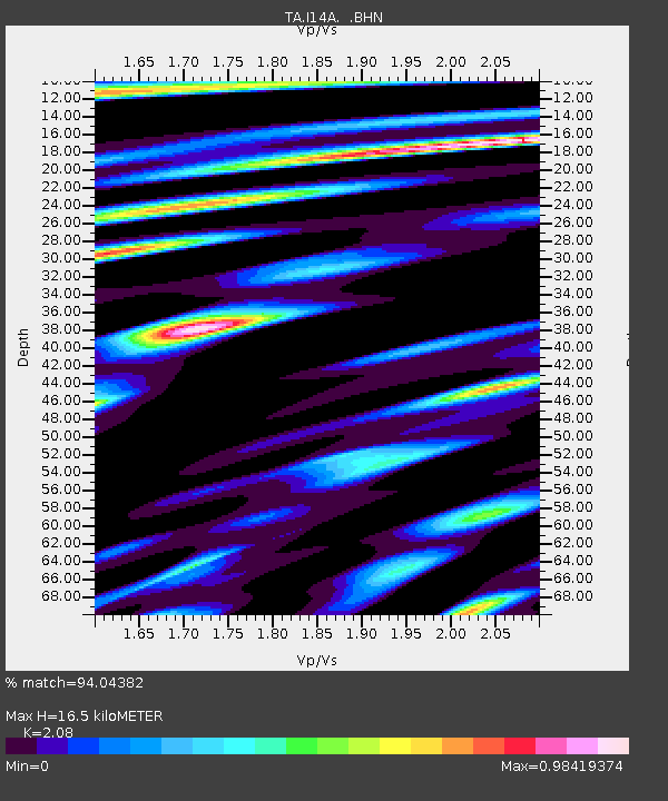
I14A Mackay, ID, USA - Earthquake Result Viewer
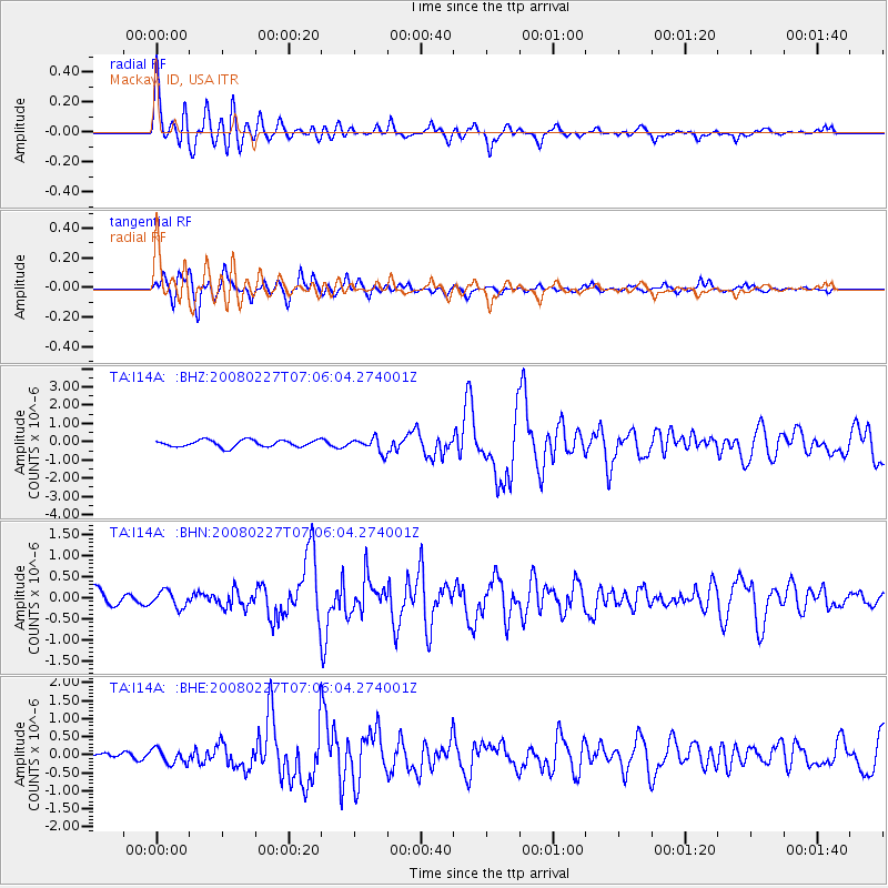
Earthquake location: Bonin Islands, Japan Region
Earthquake latitude/longitude: 26.8/142.4
Earthquake time(UTC): 2008/02/27 (058) 06:54:20 GMT
Earthquake Depth: 15 km
Earthquake Magnitude: 5.8 MB, 6.1 MS, 6.2 MW, 6.2 MW
Earthquake Catalog/Contributor: WHDF/NEIC
Network: TA USArray Transportable Network (new EarthScope stations)
Station: I14A Mackay, ID, USA
Lat/Lon: 43.93 N/113.45 W
Elevation: 1897 m
Distance: 81.2 deg
Az: 45.158 deg
Baz: 298.716 deg
Ray Param: 0.047737207
Estimated Moho Depth: 16.5 km
Estimated Crust Vp/Vs: 2.08
Assumed Crust Vp: 6.279 km/s
Estimated Crust Vs: 3.019 km/s
Estimated Crust Poisson's Ratio: 0.35
Radial Match: 94.04382 %
Radial Bump: 400
Transverse Match: 83.09522 %
Transverse Bump: 400
SOD ConfigId: 2564
Insert Time: 2010-03-06 16:42:23.013 +0000
GWidth: 2.5
Max Bumps: 400
Tol: 0.001

Signal To Noise

ChannelStoNSTALTA
TA:I14A: :BHN:20080227T07:06:04.274001Z0.98854471.9352585E-71.9576844E-7
TA:I14A: :BHE:20080227T07:06:04.274001Z1.79460332.0295958E-71.13094394E-7
TA:I14A: :BHZ:20080227T07:06:04.274001Z2.05460263.9160403E-71.9059843E-7
Arrivals
Ps2.9 SECOND
PpPs7.9 SECOND
PsPs/PpSs11 SECOND