You are here: Home > Network List > 5H - Central Virginia and South Carolina seismic monitoring experiment Stations List
> Station DAVE Dillwyn, VA > Earthquake Result Viewer
DAVE Dillwyn, VA - Earthquake Result Viewer
| Earthquake location: |
Kuril Islands |
| Earthquake latitude/longitude: |
49.1/156.4 |
| Earthquake time(UTC): |
2018/10/10 (283) 23:16:04 GMT |
| Earthquake Depth: |
33 km |
| Earthquake Magnitude: |
6.8 Mi |
| Earthquake Catalog/Contributor: |
NEIC PDE/at |
|
| Network: |
5H Central Virginia and South Carolina seismic monitoring experiment |
| Station: |
DAVE Dillwyn, VA |
| Lat/Lon: |
37.55 N/78.37 W |
| Elevation: |
130 m |
|
| Distance: |
81.0 deg |
| Az: |
41.092 deg |
| Baz: |
327.076 deg |
| Ray Param: |
0.04783397 |
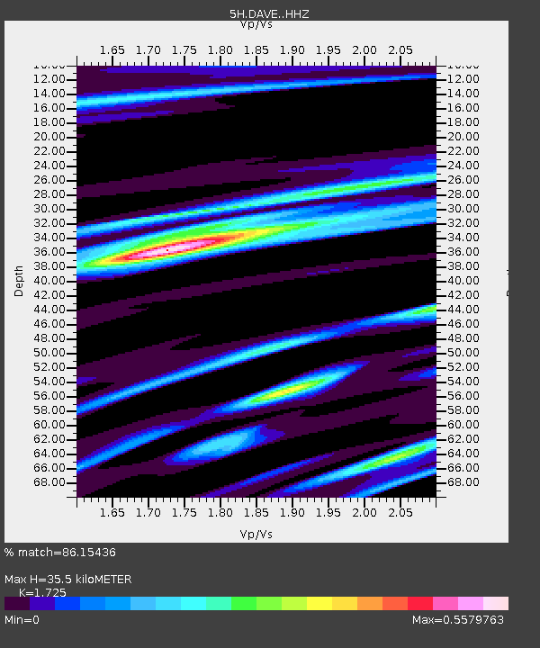
| Estimated Moho Depth: |
35.5 km |
| Estimated Crust Vp/Vs: |
1.73 |
| Assumed Crust Vp: |
6.419 km/s |
| Estimated Crust Vs: |
3.721 km/s |
| Estimated Crust Poisson's Ratio: |
0.25 |
|
| Radial Match: |
86.15436 % |
| Radial Bump: |
400 |
| Transverse Match: |
48.084812 % |
| Transverse Bump: |
400 |
| SOD ConfigId: |
13570011 |
| Insert Time: |
2019-05-01 11:41:01.736 +0000 |
| GWidth: |
2.5 |
| Max Bumps: |
400 |
| Tol: |
0.001 |
|

Signal To Noise
| Channel | StoN | STA | LTA |
| 5H:DAVE: :HHZ:20181010T23:27:43.554993Z | 3.8575063 | 1.99121E-6 | 5.16191E-7 |
| 5H:DAVE: :HHN:20181010T23:27:43.554993Z | 3.011416 | 6.145171E-7 | 2.040625E-7 |
| 5H:DAVE: :HHE:20181010T23:27:43.554993Z | 1.0735874 | 3.5816583E-7 | 3.3361593E-7 |
| Arrivals |
| Ps | 4.1 SECOND |
| PpPs | 15 SECOND |
| PsPs/PpSs | 19 SECOND |


