You are here: Home > Network List > TA - USArray Transportable Network (new EarthScope stations) Stations List
> Station I14A Mackay, ID, USA > Earthquake Result Viewer
I14A Mackay, ID, USA - Earthquake Result Viewer
| Earthquake location: |
Santa Cruz Islands Region |
| Earthquake latitude/longitude: |
-11.0/164.5 |
| Earthquake time(UTC): |
2008/07/19 (201) 09:27:01 GMT |
| Earthquake Depth: |
11 km |
| Earthquake Magnitude: |
6.1 MB, 6.4 MS, 6.6 MW, 6.6 MW |
| Earthquake Catalog/Contributor: |
WHDF/NEIC |
|
| Network: |
TA USArray Transportable Network (new EarthScope stations) |
| Station: |
I14A Mackay, ID, USA |
| Lat/Lon: |
43.93 N/113.45 W |
| Elevation: |
1897 m |
|
| Distance: |
91.9 deg |
| Az: |
45.725 deg |
| Baz: |
256.619 deg |
| Ray Param: |
0.041536357 |
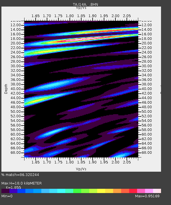
| Estimated Moho Depth: |
18.0 km |
| Estimated Crust Vp/Vs: |
1.86 |
| Assumed Crust Vp: |
6.279 km/s |
| Estimated Crust Vs: |
3.385 km/s |
| Estimated Crust Poisson's Ratio: |
0.30 |
|
| Radial Match: |
86.320244 % |
| Radial Bump: |
400 |
| Transverse Match: |
85.643295 % |
| Transverse Bump: |
400 |
| SOD ConfigId: |
2658 |
| Insert Time: |
2010-03-06 16:42:28.564 +0000 |
| GWidth: |
2.5 |
| Max Bumps: |
400 |
| Tol: |
0.001 |
|
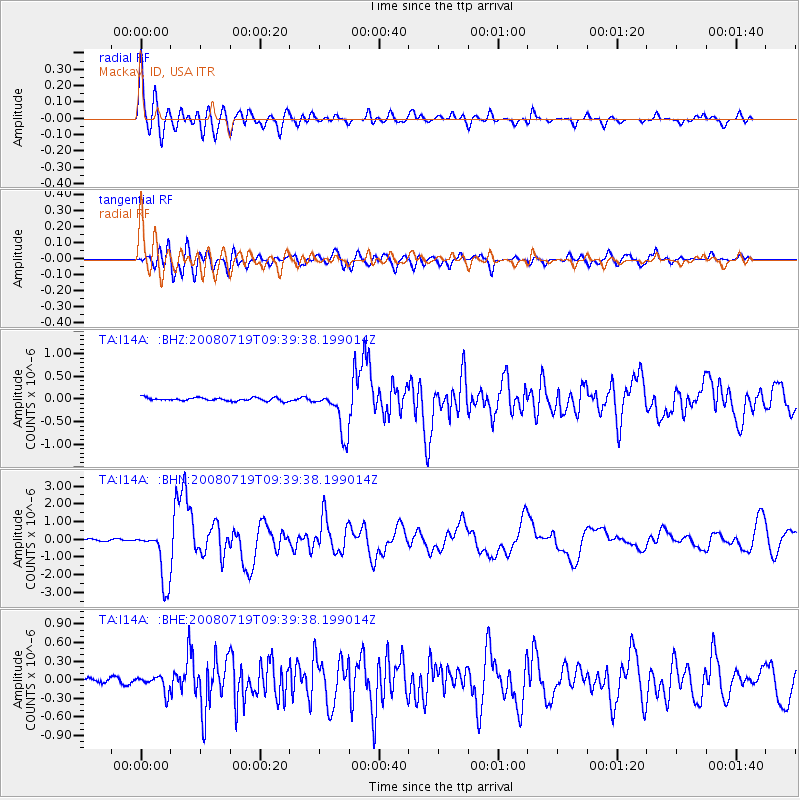
Signal To Noise
| Channel | StoN | STA | LTA |
| TA:I14A: :BHN:20080719T09:39:38.199014Z | 24.589716 | 1.5308889E-6 | 6.225728E-8 |
| TA:I14A: :BHE:20080719T09:39:38.199014Z | 2.3724046 | 1.3109067E-7 | 5.5256454E-8 |
| TA:I14A: :BHZ:20080719T09:39:38.199014Z | 13.722447 | 4.9056143E-7 | 3.574883E-8 |
| Arrivals |
| Ps | 2.5 SECOND |
| PpPs | 8.0 SECOND |
| PsPs/PpSs | 11 SECOND |


