You are here: Home > Network List > TA - USArray Transportable Network (new EarthScope stations) Stations List
> Station I14A Mackay, ID, USA > Earthquake Result Viewer
I14A Mackay, ID, USA - Earthquake Result Viewer
| Earthquake location: |
Kermadec Islands Region |
| Earthquake latitude/longitude: |
-27.4/-176.3 |
| Earthquake time(UTC): |
2009/02/18 (049) 21:53:45 GMT |
| Earthquake Depth: |
25 km |
| Earthquake Magnitude: |
6.8 MB, 7.2 MS, 6.9 MW, 6.9 MW |
| Earthquake Catalog/Contributor: |
WHDF/NEIC |
|
| Network: |
TA USArray Transportable Network (new EarthScope stations) |
| Station: |
I14A Mackay, ID, USA |
| Lat/Lon: |
43.93 N/113.45 W |
| Elevation: |
1897 m |
|
| Distance: |
91.4 deg |
| Az: |
40.036 deg |
| Baz: |
232.313 deg |
| Ray Param: |
0.041604258 |
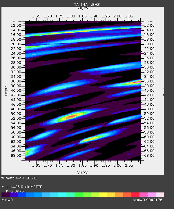
| Estimated Moho Depth: |
36.0 km |
| Estimated Crust Vp/Vs: |
2.10 |
| Assumed Crust Vp: |
6.279 km/s |
| Estimated Crust Vs: |
2.993 km/s |
| Estimated Crust Poisson's Ratio: |
0.35 |
|
| Radial Match: |
94.56501 % |
| Radial Bump: |
400 |
| Transverse Match: |
82.60853 % |
| Transverse Bump: |
400 |
| SOD ConfigId: |
2658 |
| Insert Time: |
2010-03-06 16:42:35.184 +0000 |
| GWidth: |
2.5 |
| Max Bumps: |
400 |
| Tol: |
0.001 |
|

Signal To Noise
| Channel | StoN | STA | LTA |
| TA:I14A: :BHZ:20090218T22:06:17.300015Z | 8.184581 | 1.230746E-6 | 1.5037372E-7 |
| TA:I14A: :BHN:20090218T22:06:17.300015Z | 0.78532654 | 2.8530224E-7 | 3.632912E-7 |
| TA:I14A: :BHE:20090218T22:06:17.300015Z | 1.7269976 | 3.453166E-7 | 1.99952E-7 |
| Arrivals |
| Ps | 6.4 SECOND |
| PpPs | 17 SECOND |
| PsPs/PpSs | 24 SECOND |


