You are here: Home > Network List > AU - Australian Seismological Centre Stations List
> Station WB2 Warramunga Array, Australia > Earthquake Result Viewer
WB2 Warramunga Array, Australia - Earthquake Result Viewer
| Earthquake location: |
Kuril Islands |
| Earthquake latitude/longitude: |
49.1/156.4 |
| Earthquake time(UTC): |
2018/10/10 (283) 23:16:04 GMT |
| Earthquake Depth: |
33 km |
| Earthquake Magnitude: |
6.8 Mi |
| Earthquake Catalog/Contributor: |
NEIC PDE/at |
|
| Network: |
AU Australian Seismological Centre |
| Station: |
WB2 Warramunga Array, Australia |
| Lat/Lon: |
19.94 S/134.35 E |
| Elevation: |
388 m |
|
| Distance: |
71.5 deg |
| Az: |
201.866 deg |
| Baz: |
15.082 deg |
| Ray Param: |
0.05424725 |
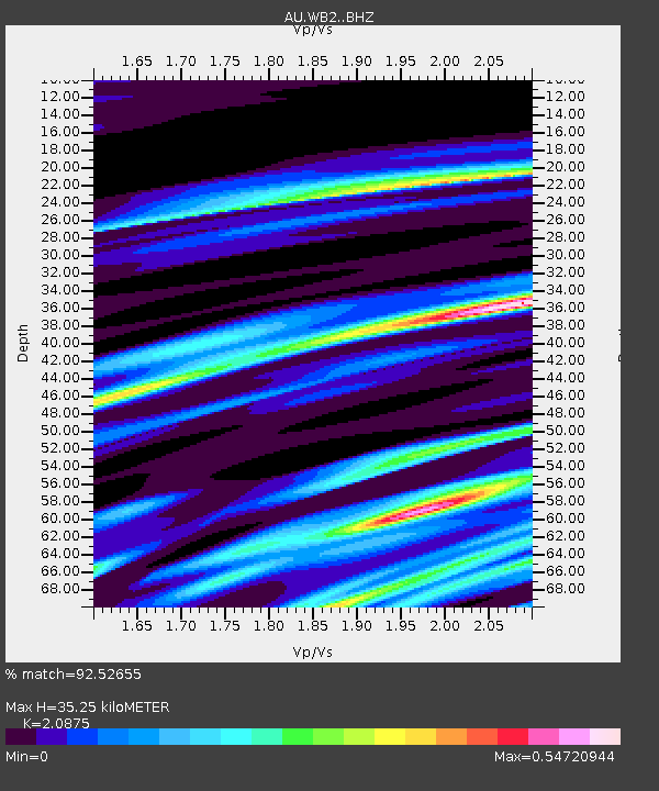
| Estimated Moho Depth: |
35.25 km |
| Estimated Crust Vp/Vs: |
2.09 |
| Assumed Crust Vp: |
6.642 km/s |
| Estimated Crust Vs: |
3.182 km/s |
| Estimated Crust Poisson's Ratio: |
0.35 |
|
| Radial Match: |
92.52655 % |
| Radial Bump: |
400 |
| Transverse Match: |
60.613136 % |
| Transverse Bump: |
400 |
| SOD ConfigId: |
13570011 |
| Insert Time: |
2019-05-01 11:41:57.956 +0000 |
| GWidth: |
2.5 |
| Max Bumps: |
400 |
| Tol: |
0.001 |
|

Signal To Noise
| Channel | StoN | STA | LTA |
| AU:WB2: :BHZ:20181010T23:26:51.000Z | 5.42593 | 1.5306155E-6 | 2.8209274E-7 |
| AU:WB2: :BHN:20181010T23:26:51.000Z | 3.0916326 | 6.675855E-7 | 2.15933E-7 |
| AU:WB2: :BHE:20181010T23:26:51.000Z | 3.2301204 | 3.0732735E-7 | 9.514424E-8 |
| Arrivals |
| Ps | 6.0 SECOND |
| PpPs | 16 SECOND |
| PsPs/PpSs | 22 SECOND |


