You are here: Home > Network List > AU - Australian Seismological Centre Stations List
> Station XMIS Christmas Island Grants Well > Earthquake Result Viewer
XMIS Christmas Island Grants Well - Earthquake Result Viewer
| Earthquake location: |
Kuril Islands |
| Earthquake latitude/longitude: |
49.1/156.4 |
| Earthquake time(UTC): |
2018/10/10 (283) 23:16:04 GMT |
| Earthquake Depth: |
33 km |
| Earthquake Magnitude: |
6.8 Mi |
| Earthquake Catalog/Contributor: |
NEIC PDE/at |
|
| Network: |
AU Australian Seismological Centre |
| Station: |
XMIS Christmas Island Grants Well |
| Lat/Lon: |
10.48 S/105.65 E |
| Elevation: |
210 m |
|
| Distance: |
74.2 deg |
| Az: |
232.34 deg |
| Baz: |
31.939 deg |
| Ray Param: |
0.05246645 |
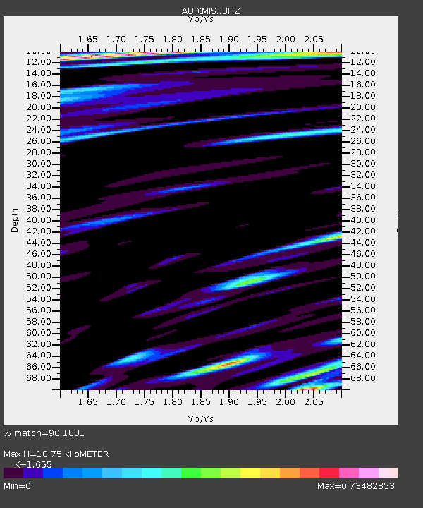
| Estimated Moho Depth: |
10.75 km |
| Estimated Crust Vp/Vs: |
1.65 |
| Assumed Crust Vp: |
4.157 km/s |
| Estimated Crust Vs: |
2.512 km/s |
| Estimated Crust Poisson's Ratio: |
0.21 |
|
| Radial Match: |
90.1831 % |
| Radial Bump: |
400 |
| Transverse Match: |
75.28859 % |
| Transverse Bump: |
400 |
| SOD ConfigId: |
13570011 |
| Insert Time: |
2019-05-01 11:42:01.386 +0000 |
| GWidth: |
2.5 |
| Max Bumps: |
400 |
| Tol: |
0.001 |
|

Signal To Noise
| Channel | StoN | STA | LTA |
| AU:XMIS: :BHZ:20181010T23:27:06.31897Z | 6.5952735 | 3.0894887E-6 | 4.6843982E-7 |
| AU:XMIS: :BHN:20181010T23:27:06.31897Z | 2.3257666 | 1.2062883E-6 | 5.1866266E-7 |
| AU:XMIS: :BHE:20181010T23:27:06.31897Z | 1.8113271 | 9.908621E-7 | 5.470365E-7 |
| Arrivals |
| Ps | 1.7 SECOND |
| PpPs | 6.8 SECOND |
| PsPs/PpSs | 8.5 SECOND |


