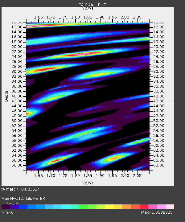
I14A Mackay, ID, USA - Earthquake Result Viewer
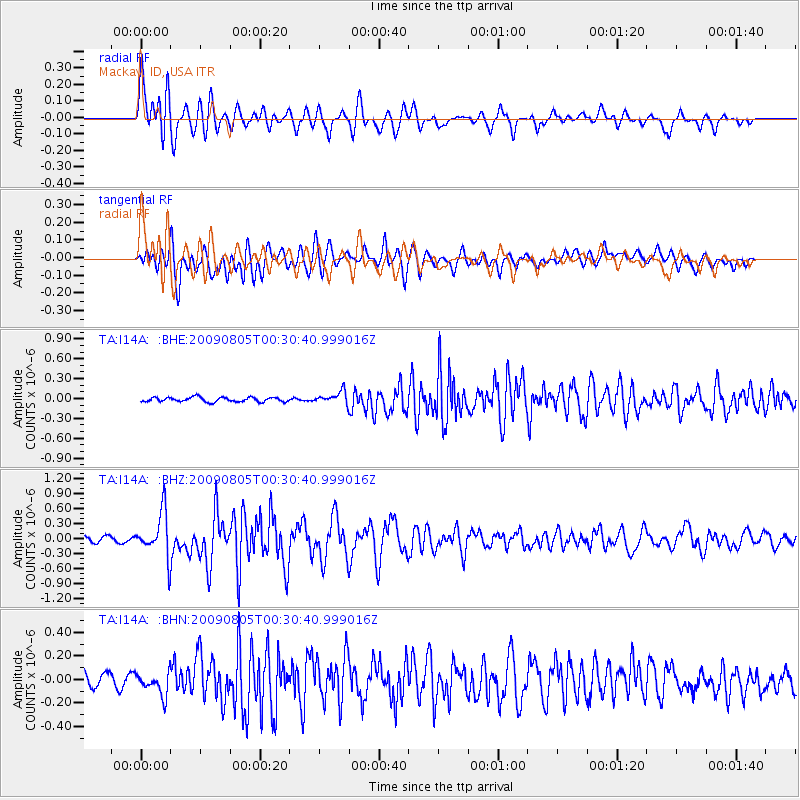
Earthquake location: Southwestern Ryukyu Isl., Japan
Earthquake latitude/longitude: 24.2/125.1
Earthquake time(UTC): 2009/08/05 (217) 00:17:58 GMT
Earthquake Depth: 25 km
Earthquake Magnitude: 5.9 MB, 5.9 MS, 6.2 MW, 6.1 MW
Earthquake Catalog/Contributor: WHDF/NEIC
Network: TA USArray Transportable Network (new EarthScope stations)
Station: I14A Mackay, ID, USA
Lat/Lon: 43.93 N/113.45 W
Elevation: 1897 m
Distance: 93.6 deg
Az: 38.138 deg
Baz: 308.714 deg
Ray Param: 0.04123071
Estimated Moho Depth: 11.5 km
Estimated Crust Vp/Vs: 1.60
Assumed Crust Vp: 6.279 km/s
Estimated Crust Vs: 3.924 km/s
Estimated Crust Poisson's Ratio: 0.18
Radial Match: 84.23624 %
Radial Bump: 400
Transverse Match: 83.77017 %
Transverse Bump: 400
SOD ConfigId: 2622
Insert Time: 2010-03-06 16:42:43.561 +0000
GWidth: 2.5
Max Bumps: 400
Tol: 0.001

Signal To Noise

ChannelStoNSTALTA
TA:I14A: :BHZ:20090805T00:30:40.999016Z5.60636334.399291E-77.84696E-8
TA:I14A: :BHN:20090805T00:30:40.999016Z1.38429679.5615796E-86.907175E-8
TA:I14A: :BHE:20090805T00:30:40.999016Z2.764229.4383914E-83.414486E-8
Arrivals
Ps1.1 SECOND
PpPs4.7 SECOND
PsPs/PpSs5.8 SECOND