You are here: Home > Network List > CA - Catalan Seismic Network Stations List
> Station CGAR Garraf > Earthquake Result Viewer
CGAR Garraf - Earthquake Result Viewer
| Earthquake location: |
Kuril Islands |
| Earthquake latitude/longitude: |
49.1/156.4 |
| Earthquake time(UTC): |
2018/10/10 (283) 23:16:04 GMT |
| Earthquake Depth: |
33 km |
| Earthquake Magnitude: |
6.8 Mi |
| Earthquake Catalog/Contributor: |
NEIC PDE/at |
|
| Network: |
CA Catalan Seismic Network |
| Station: |
CGAR Garraf |
| Lat/Lon: |
41.29 N/1.91 E |
| Elevation: |
584 m |
|
| Distance: |
87.2 deg |
| Az: |
341.037 deg |
| Baz: |
16.465 deg |
| Ray Param: |
0.0434376 |
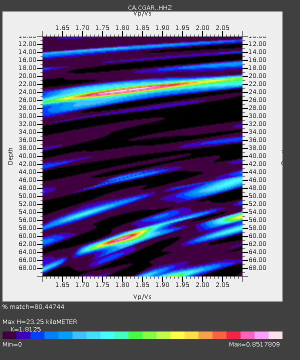
| Estimated Moho Depth: |
23.25 km |
| Estimated Crust Vp/Vs: |
1.81 |
| Assumed Crust Vp: |
6.391 km/s |
| Estimated Crust Vs: |
3.526 km/s |
| Estimated Crust Poisson's Ratio: |
0.28 |
|
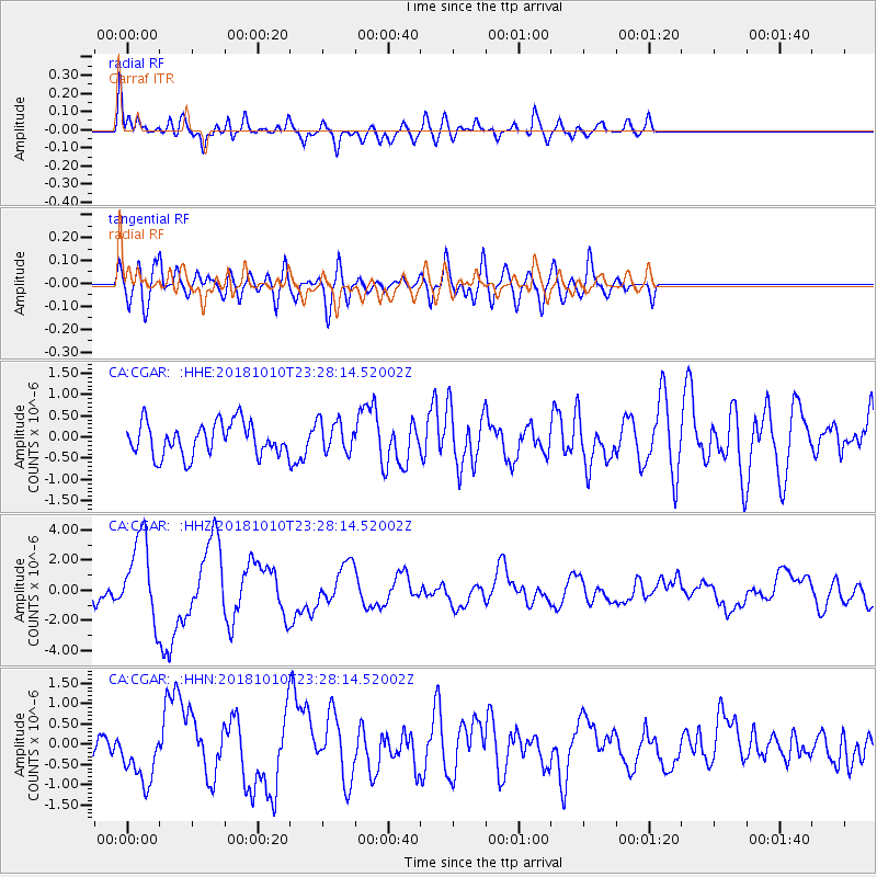
| Radial Match: |
80.44744 % |
| Radial Bump: |
400 |
| Transverse Match: |
57.964073 % |
| Transverse Bump: |
400 |
| SOD ConfigId: |
13570011 |
| Insert Time: |
2019-05-01 11:42:30.820 +0000 |
| GWidth: |
2.5 |
| Max Bumps: |
400 |
| Tol: |
0.001 |
|
Signal To Noise
| Channel | StoN | STA | LTA |
| CA:CGAR: :HHZ:20181010T23:28:14.52002Z | 6.801833 | 2.7327178E-6 | 4.0176198E-7 |
| CA:CGAR: :HHN:20181010T23:28:14.52002Z | 1.4229861 | 6.495599E-7 | 4.564766E-7 |
| CA:CGAR: :HHE:20181010T23:28:14.52002Z | 0.9999621 | 4.0478614E-7 | 4.0480148E-7 |
| Arrivals |
| Ps | 3.0 SECOND |
| PpPs | 10 SECOND |
| PsPs/PpSs | 13 SECOND |


