You are here: Home > Network List > CB - China National Seismic Network Stations List
> Station CD2 Chengdou,Sichuan Province > Earthquake Result Viewer
CD2 Chengdou,Sichuan Province - Earthquake Result Viewer
| Earthquake location: |
Kuril Islands |
| Earthquake latitude/longitude: |
49.1/156.4 |
| Earthquake time(UTC): |
2018/10/10 (283) 23:16:04 GMT |
| Earthquake Depth: |
33 km |
| Earthquake Magnitude: |
6.8 Mi |
| Earthquake Catalog/Contributor: |
NEIC PDE/at |
|
| Network: |
CB China National Seismic Network |
| Station: |
CD2 Chengdou,Sichuan Province |
| Lat/Lon: |
30.91 N/103.76 E |
| Elevation: |
653 m |
|
| Distance: |
43.3 deg |
| Az: |
265.222 deg |
| Baz: |
49.644 deg |
| Ray Param: |
0.07258681 |
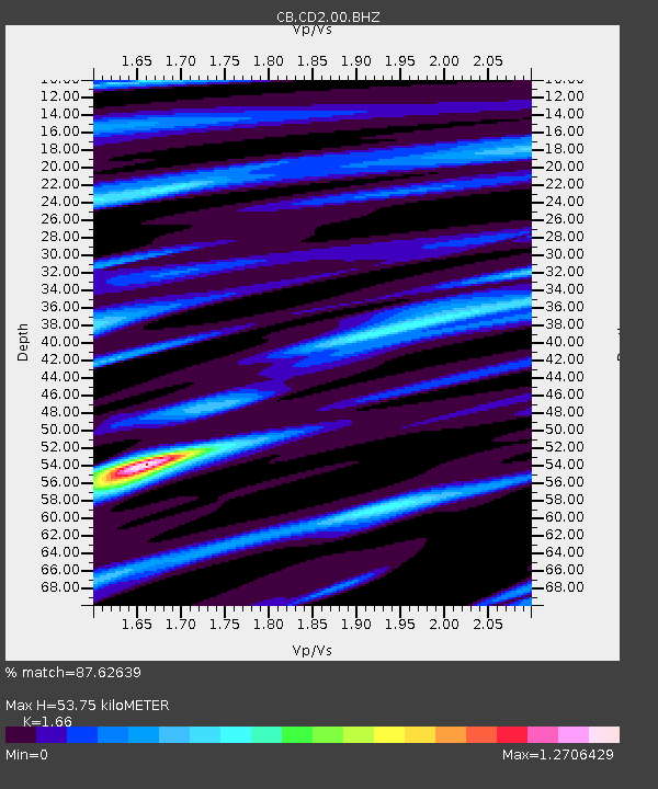
| Estimated Moho Depth: |
53.75 km |
| Estimated Crust Vp/Vs: |
1.66 |
| Assumed Crust Vp: |
6.159 km/s |
| Estimated Crust Vs: |
3.71 km/s |
| Estimated Crust Poisson's Ratio: |
0.22 |
|
| Radial Match: |
87.62639 % |
| Radial Bump: |
386 |
| Transverse Match: |
79.46922 % |
| Transverse Bump: |
400 |
| SOD ConfigId: |
13570011 |
| Insert Time: |
2019-05-01 11:42:38.485 +0000 |
| GWidth: |
2.5 |
| Max Bumps: |
400 |
| Tol: |
0.001 |
|

Signal To Noise
| Channel | StoN | STA | LTA |
| CB:CD2:00:BHZ:20181010T23:23:31.079987Z | 40.7359 | 1.1968291E-5 | 2.9380203E-7 |
| CB:CD2:00:BHN:20181010T23:23:31.079987Z | 15.419247 | 3.232687E-6 | 2.0965271E-7 |
| CB:CD2:00:BHE:20181010T23:23:31.079987Z | 20.520432 | 3.8828834E-6 | 1.8922036E-7 |
| Arrivals |
| Ps | 6.1 SECOND |
| PpPs | 22 SECOND |
| PsPs/PpSs | 28 SECOND |


