You are here: Home > Network List > CI - Caltech Regional Seismic Network Stations List
> Station BAR Barrett, Tecate, CA, USA > Earthquake Result Viewer
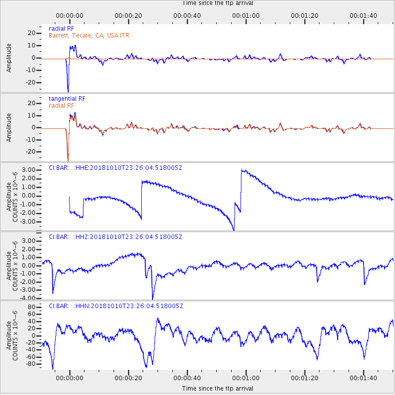
BAR Barrett, Tecate, CA, USA - Earthquake Result Viewer
*The percent match for this event was below the threshold and hence no stack was calculated.
| Earthquake location: |
Kuril Islands |
| Earthquake latitude/longitude: |
49.1/156.4 |
| Earthquake time(UTC): |
2018/10/10 (283) 23:16:04 GMT |
| Earthquake Depth: |
33 km |
| Earthquake Magnitude: |
6.8 Mi |
| Earthquake Catalog/Contributor: |
NEIC PDE/at |
|
| Network: |
CI Caltech Regional Seismic Network |
| Station: |
BAR Barrett, Tecate, CA, USA |
| Lat/Lon: |
32.68 N/116.67 W |
| Elevation: |
521 m |
|
| Distance: |
64.2 deg |
| Az: |
69.246 deg |
| Baz: |
313.217 deg |
| Ray Param: |
$rayparam |
*The percent match for this event was below the threshold and hence was not used in the summary stack. |
|
| Radial Match: |
80.41699 % |
| Radial Bump: |
400 |
| Transverse Match: |
79.95373 % |
| Transverse Bump: |
400 |
| SOD ConfigId: |
13570011 |
| Insert Time: |
2019-05-01 11:42:55.171 +0000 |
| GWidth: |
2.5 |
| Max Bumps: |
400 |
| Tol: |
0.001 |
|
Signal To Noise
| Channel | StoN | STA | LTA |
| CI:BAR: :HHZ:20181010T23:26:04.518005Z | 1.1657685 | 7.534177E-7 | 6.4628415E-7 |
| CI:BAR: :HHN:20181010T23:26:04.518005Z | 1.140959 | 3.0532323E-5 | 2.6760228E-5 |
| CI:BAR: :HHE:20181010T23:26:04.518005Z | 2.2086809 | 1.981349E-6 | 8.970734E-7 |
| Arrivals |
| Ps | |
| PpPs | |
| PsPs/PpSs | |


