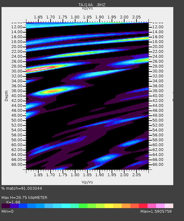
I14A Mackay, ID, USA - Earthquake Result Viewer
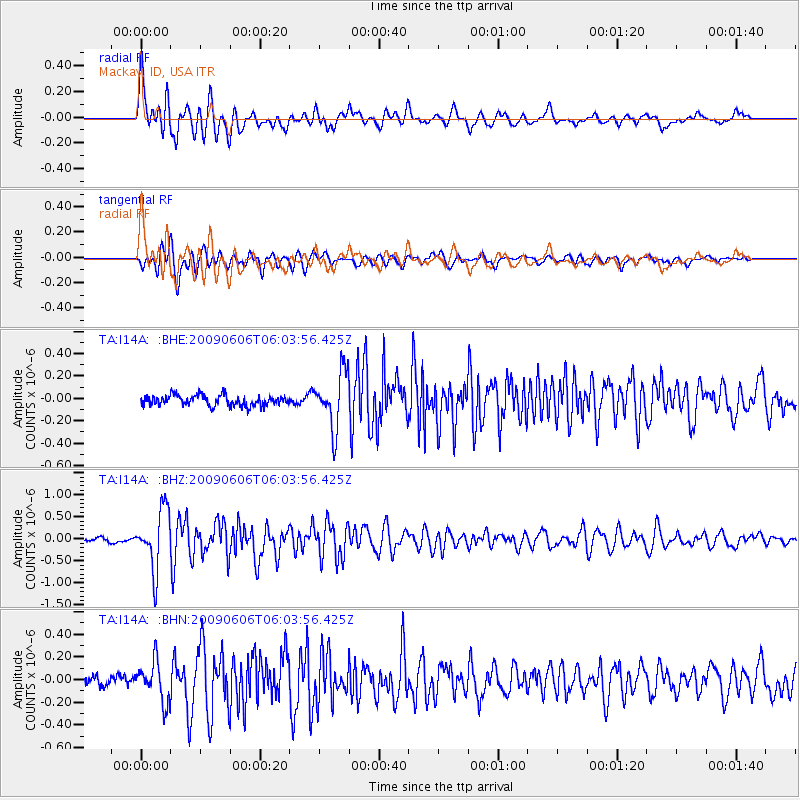
Earthquake location: Near East Coast Of Honshu, Japan
Earthquake latitude/longitude: 35.5/140.9
Earthquake time(UTC): 2009/06/06 (157) 05:52:43 GMT
Earthquake Depth: 34 km
Earthquake Magnitude: 5.8 MB, 5.4 MS, 5.8 MW, 5.7 MW
Earthquake Catalog/Contributor: WHDF/NEIC
Network: TA USArray Transportable Network (new EarthScope stations)
Station: I14A Mackay, ID, USA
Lat/Lon: 43.93 N/113.45 W
Elevation: 1897 m
Distance: 76.1 deg
Az: 45.795 deg
Baz: 305.932 deg
Ray Param: 0.051187057
Estimated Moho Depth: 28.75 km
Estimated Crust Vp/Vs: 1.66
Assumed Crust Vp: 6.279 km/s
Estimated Crust Vs: 3.782 km/s
Estimated Crust Poisson's Ratio: 0.22
Radial Match: 91.003044 %
Radial Bump: 400
Transverse Match: 90.087296 %
Transverse Bump: 400
SOD ConfigId: 2648
Insert Time: 2010-03-06 16:42:57.709 +0000
GWidth: 2.5
Max Bumps: 400
Tol: 0.001

Signal To Noise

ChannelStoNSTALTA
TA:I14A: :BHZ:20090606T06:03:56.425Z10.3743926.734814E-76.491768E-8
TA:I14A: :BHN:20090606T06:03:56.425Z3.79800871.7389861E-74.5786788E-8
TA:I14A: :BHE:20090606T06:03:56.425Z5.36581662.4923827E-74.6449273E-8
Arrivals
Ps3.1 SECOND
PpPs12 SECOND
PsPs/PpSs15 SECOND