You are here: Home > Network List > TA - USArray Transportable Network (new EarthScope stations) Stations List
> Station I14A Mackay, ID, USA > Earthquake Result Viewer
I14A Mackay, ID, USA - Earthquake Result Viewer
| Earthquake location: |
Costa Rica |
| Earthquake latitude/longitude: |
8.5/-83.2 |
| Earthquake time(UTC): |
2009/03/11 (070) 17:24:36 GMT |
| Earthquake Depth: |
14 km |
| Earthquake Magnitude: |
5.8 MB, 5.6 MS, 5.9 MW, 5.9 MW |
| Earthquake Catalog/Contributor: |
WHDF/NEIC |
|
| Network: |
TA USArray Transportable Network (new EarthScope stations) |
| Station: |
I14A Mackay, ID, USA |
| Lat/Lon: |
43.93 N/113.45 W |
| Elevation: |
1897 m |
|
| Distance: |
44.0 deg |
| Az: |
328.434 deg |
| Baz: |
134.221 deg |
| Ray Param: |
0.072161034 |
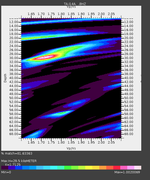
| Estimated Moho Depth: |
29.5 km |
| Estimated Crust Vp/Vs: |
1.71 |
| Assumed Crust Vp: |
6.279 km/s |
| Estimated Crust Vs: |
3.666 km/s |
| Estimated Crust Poisson's Ratio: |
0.24 |
|
| Radial Match: |
81.63363 % |
| Radial Bump: |
289 |
| Transverse Match: |
61.761997 % |
| Transverse Bump: |
400 |
| SOD ConfigId: |
2658 |
| Insert Time: |
2010-03-06 16:43:04.948 +0000 |
| GWidth: |
2.5 |
| Max Bumps: |
400 |
| Tol: |
0.001 |
|

Signal To Noise
| Channel | StoN | STA | LTA |
| TA:I14A: :BHZ:20090311T17:32:12.750015Z | 4.344163 | 7.8807903E-7 | 1.8141102E-7 |
| TA:I14A: :BHN:20090311T17:32:12.750015Z | 3.6228733 | 4.174863E-7 | 1.1523624E-7 |
| TA:I14A: :BHE:20090311T17:32:12.750015Z | 2.0422583 | 2.8130847E-7 | 1.3774383E-7 |
| Arrivals |
| Ps | 3.6 SECOND |
| PpPs | 12 SECOND |
| PsPs/PpSs | 16 SECOND |


