You are here: Home > Network List > TA - USArray Transportable Network (new EarthScope stations) Stations List
> Station I14A Mackay, ID, USA > Earthquake Result Viewer
I14A Mackay, ID, USA - Earthquake Result Viewer
| Earthquake location: |
South Of Panama |
| Earthquake latitude/longitude: |
5.7/-82.8 |
| Earthquake time(UTC): |
2009/03/12 (071) 23:23:34 GMT |
| Earthquake Depth: |
9.0 km |
| Earthquake Magnitude: |
6.1 MB, 5.9 MS, 6.3 MW, 6.2 MW |
| Earthquake Catalog/Contributor: |
WHDF/NEIC |
|
| Network: |
TA USArray Transportable Network (new EarthScope stations) |
| Station: |
I14A Mackay, ID, USA |
| Lat/Lon: |
43.93 N/113.45 W |
| Elevation: |
1897 m |
|
| Distance: |
46.7 deg |
| Az: |
329.535 deg |
| Baz: |
135.708 deg |
| Ray Param: |
0.07051231 |
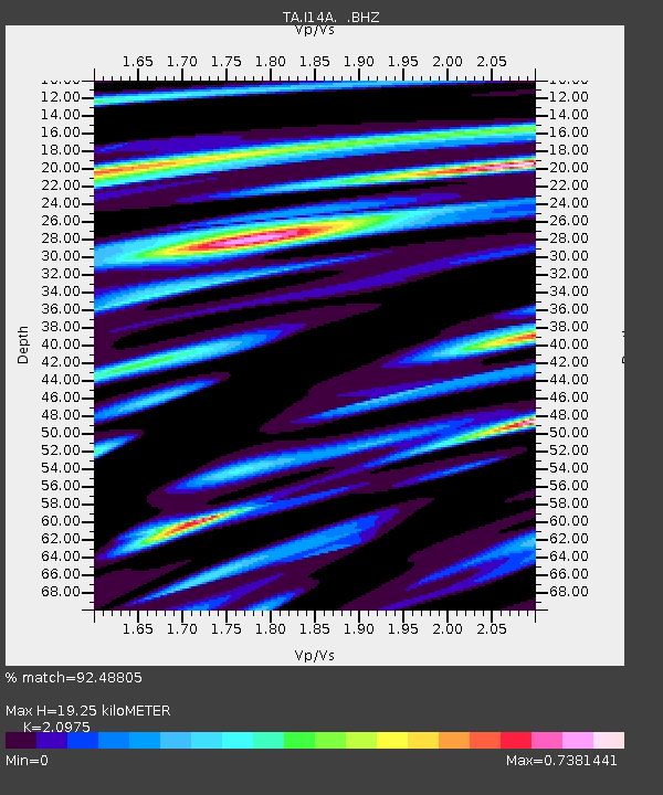
| Estimated Moho Depth: |
19.25 km |
| Estimated Crust Vp/Vs: |
2.10 |
| Assumed Crust Vp: |
6.279 km/s |
| Estimated Crust Vs: |
2.993 km/s |
| Estimated Crust Poisson's Ratio: |
0.35 |
|
| Radial Match: |
92.48805 % |
| Radial Bump: |
400 |
| Transverse Match: |
81.75782 % |
| Transverse Bump: |
400 |
| SOD ConfigId: |
2658 |
| Insert Time: |
2010-03-06 16:43:08.274 +0000 |
| GWidth: |
2.5 |
| Max Bumps: |
400 |
| Tol: |
0.001 |
|

Signal To Noise
| Channel | StoN | STA | LTA |
| TA:I14A: :BHZ:20090312T23:31:32.598992Z | 5.1648645 | 5.2648596E-7 | 1.0193606E-7 |
| TA:I14A: :BHN:20090312T23:31:32.598992Z | 0.71813697 | 9.8511244E-8 | 1.3717612E-7 |
| TA:I14A: :BHE:20090312T23:31:32.598992Z | 2.05043 | 1.645241E-7 | 8.023882E-8 |
| Arrivals |
| Ps | 3.5 SECOND |
| PpPs | 9.0 SECOND |
| PsPs/PpSs | 13 SECOND |


