You are here: Home > Network List > CN - Canadian National Seismograph Network Stations List
> Station VLDQ VALDOR, QC > Earthquake Result Viewer
VLDQ VALDOR, QC - Earthquake Result Viewer
| Earthquake location: |
Kuril Islands |
| Earthquake latitude/longitude: |
49.1/156.4 |
| Earthquake time(UTC): |
2018/10/10 (283) 23:16:04 GMT |
| Earthquake Depth: |
33 km |
| Earthquake Magnitude: |
6.8 Mi |
| Earthquake Catalog/Contributor: |
NEIC PDE/at |
|
| Network: |
CN Canadian National Seismograph Network |
| Station: |
VLDQ VALDOR, QC |
| Lat/Lon: |
48.19 N/77.76 W |
| Elevation: |
93 m |
|
| Distance: |
72.4 deg |
| Az: |
34.687 deg |
| Baz: |
326.015 deg |
| Ray Param: |
0.053643767 |
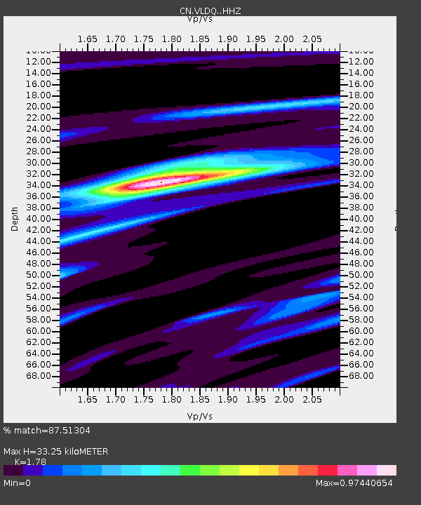
| Estimated Moho Depth: |
33.25 km |
| Estimated Crust Vp/Vs: |
1.78 |
| Assumed Crust Vp: |
6.61 km/s |
| Estimated Crust Vs: |
3.713 km/s |
| Estimated Crust Poisson's Ratio: |
0.27 |
|
| Radial Match: |
87.51304 % |
| Radial Bump: |
328 |
| Transverse Match: |
68.9218 % |
| Transverse Bump: |
400 |
| SOD ConfigId: |
13570011 |
| Insert Time: |
2019-05-01 11:43:59.789 +0000 |
| GWidth: |
2.5 |
| Max Bumps: |
400 |
| Tol: |
0.001 |
|

Signal To Noise
| Channel | StoN | STA | LTA |
| CN:VLDQ: :HHZ:20181010T23:26:54.780029Z | 9.584873 | 2.4382591E-6 | 2.5438615E-7 |
| CN:VLDQ: :HHN:20181010T23:26:54.780029Z | 6.260109 | 8.6052387E-7 | 1.3746148E-7 |
| CN:VLDQ: :HHE:20181010T23:26:54.780029Z | 3.5380292 | 6.2010747E-7 | 1.7526918E-7 |
| Arrivals |
| Ps | 4.1 SECOND |
| PpPs | 13 SECOND |
| PsPs/PpSs | 18 SECOND |


