You are here: Home > Network List > TA - USArray Transportable Network (new EarthScope stations) Stations List
> Station I14A Mackay, ID, USA > Earthquake Result Viewer
I14A Mackay, ID, USA - Earthquake Result Viewer
| Earthquake location: |
East Of Kuril Islands |
| Earthquake latitude/longitude: |
46.0/154.2 |
| Earthquake time(UTC): |
2007/10/25 (298) 13:50:02 GMT |
| Earthquake Depth: |
10 km |
| Earthquake Magnitude: |
6.0 MB, 5.7 MS, 6.1 MW, 5.9 MW |
| Earthquake Catalog/Contributor: |
WHDF/NEIC |
|
| Network: |
TA USArray Transportable Network (new EarthScope stations) |
| Station: |
I14A Mackay, ID, USA |
| Lat/Lon: |
43.93 N/113.45 W |
| Elevation: |
1897 m |
|
| Distance: |
61.6 deg |
| Az: |
55.144 deg |
| Baz: |
307.671 deg |
| Ray Param: |
0.060760874 |
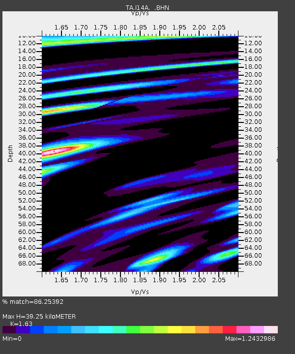
| Estimated Moho Depth: |
39.25 km |
| Estimated Crust Vp/Vs: |
1.63 |
| Assumed Crust Vp: |
6.279 km/s |
| Estimated Crust Vs: |
3.852 km/s |
| Estimated Crust Poisson's Ratio: |
0.20 |
|
| Radial Match: |
86.25392 % |
| Radial Bump: |
400 |
| Transverse Match: |
83.04278 % |
| Transverse Bump: |
400 |
| SOD ConfigId: |
2564 |
| Insert Time: |
2010-03-06 16:43:31.303 +0000 |
| GWidth: |
2.5 |
| Max Bumps: |
400 |
| Tol: |
0.001 |
|
Signal To Noise
| Channel | StoN | STA | LTA |
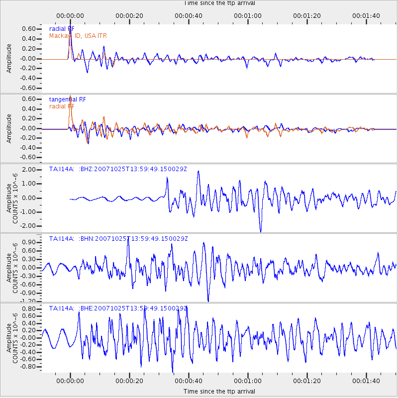
| TA:I14A: :BHN:20071025T13:59:49.150029Z | 1.483168 | 1.5199477E-7 | 1.024798E-7 |
| TA:I14A: :BHE:20071025T13:59:49.150029Z | 1.9278502 | 2.9737015E-7 | 1.542496E-7 |
| TA:I14A: :BHZ:20071025T13:59:49.150029Z | 6.2394257 | 5.7030684E-7 | 9.140375E-8 |
| Arrivals |
| Ps | 4.1 SECOND |
| PpPs | 16 SECOND |
| PsPs/PpSs | 20 SECOND |


