You are here: Home > Network List > TA - USArray Transportable Network (new EarthScope stations) Stations List
> Station I14A Mackay, ID, USA > Earthquake Result Viewer
I14A Mackay, ID, USA - Earthquake Result Viewer
| Earthquake location: |
Near West Coast Of Colombia |
| Earthquake latitude/longitude: |
3.0/-78.0 |
| Earthquake time(UTC): |
2007/09/10 (253) 01:49:14 GMT |
| Earthquake Depth: |
31 km |
| Earthquake Magnitude: |
6.1 MB, 6.7 MS, 6.8 MW |
| Earthquake Catalog/Contributor: |
WHDF/NEIC |
|
| Network: |
TA USArray Transportable Network (new EarthScope stations) |
| Station: |
I14A Mackay, ID, USA |
| Lat/Lon: |
43.93 N/113.45 W |
| Elevation: |
1897 m |
|
| Distance: |
51.4 deg |
| Az: |
327.565 deg |
| Baz: |
132.157 deg |
| Ray Param: |
0.06735443 |
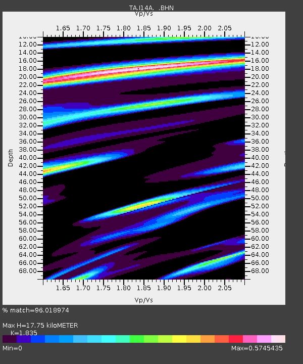
| Estimated Moho Depth: |
17.75 km |
| Estimated Crust Vp/Vs: |
1.84 |
| Assumed Crust Vp: |
6.279 km/s |
| Estimated Crust Vs: |
3.422 km/s |
| Estimated Crust Poisson's Ratio: |
0.29 |
|
| Radial Match: |
96.018974 % |
| Radial Bump: |
331 |
| Transverse Match: |
85.27048 % |
| Transverse Bump: |
400 |
| SOD ConfigId: |
2564 |
| Insert Time: |
2010-03-06 16:43:36.584 +0000 |
| GWidth: |
2.5 |
| Max Bumps: |
400 |
| Tol: |
0.001 |
|

Signal To Noise
| Channel | StoN | STA | LTA |
| TA:I14A: :BHN:20070910T01:57:45.773009Z | 3.7272823 | 4.077469E-7 | 1.0939523E-7 |
| TA:I14A: :BHE:20070910T01:57:45.773009Z | 5.4920826 | 4.7013128E-7 | 8.5601634E-8 |
| TA:I14A: :BHZ:20070910T01:57:45.773009Z | 12.511067 | 1.3519327E-6 | 1.0805894E-7 |
| Arrivals |
| Ps | 2.5 SECOND |
| PpPs | 7.6 SECOND |
| PsPs/PpSs | 10 SECOND |


