You are here: Home > Network List > UU - University of Utah Regional Network Stations List
> Station SRU San Rafael Swell, UT, USA > Earthquake Result Viewer
SRU San Rafael Swell, UT, USA - Earthquake Result Viewer
| Earthquake location: |
Mariana Islands |
| Earthquake latitude/longitude: |
18.5/145.5 |
| Earthquake time(UTC): |
2016/07/29 (211) 21:18:25 GMT |
| Earthquake Depth: |
212 km |
| Earthquake Magnitude: |
7.7 MWW, 7.7 MWB, 7.7 MI |
| Earthquake Catalog/Contributor: |
NEIC PDE/NEIC COMCAT |
|
| Network: |
UU University of Utah Regional Network |
| Station: |
SRU San Rafael Swell, UT, USA |
| Lat/Lon: |
39.11 N/110.52 W |
| Elevation: |
1804 m |
|
| Distance: |
88.8 deg |
| Az: |
49.044 deg |
| Baz: |
292.913 deg |
| Ray Param: |
0.041809693 |
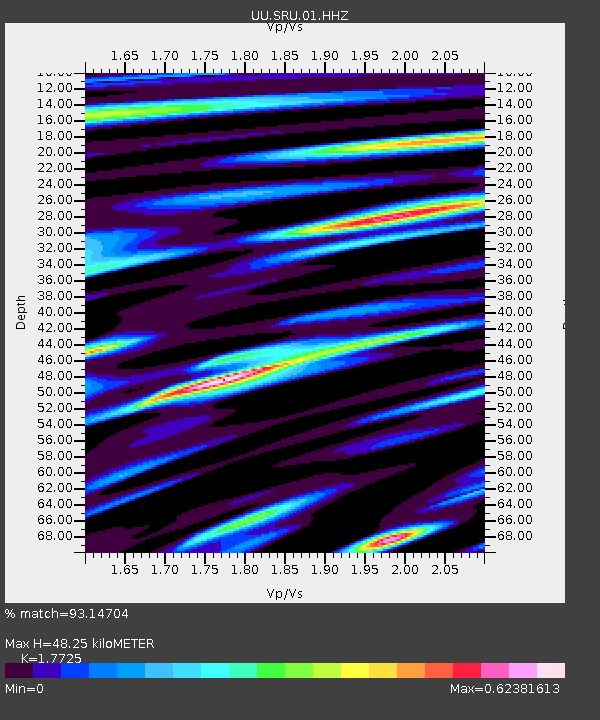
| Estimated Moho Depth: |
48.25 km |
| Estimated Crust Vp/Vs: |
1.77 |
| Assumed Crust Vp: |
6.207 km/s |
| Estimated Crust Vs: |
3.502 km/s |
| Estimated Crust Poisson's Ratio: |
0.27 |
|
| Radial Match: |
93.14704 % |
| Radial Bump: |
400 |
| Transverse Match: |
89.04095 % |
| Transverse Bump: |
400 |
| SOD ConfigId: |
1634031 |
| Insert Time: |
2016-08-12 21:31:52.722 +0000 |
| GWidth: |
2.5 |
| Max Bumps: |
400 |
| Tol: |
0.001 |
|

Signal To Noise
| Channel | StoN | STA | LTA |
| UU:SRU:01:HHZ:20160729T21:30:24.305005Z | 167.84358 | 1.1081534E-5 | 6.602298E-8 |
| UU:SRU:01:HHN:20160729T21:30:24.305005Z | 4.2760906 | 1.5400121E-6 | 3.6014487E-7 |
| UU:SRU:01:HHE:20160729T21:30:24.305005Z | 94.91387 | 2.7772203E-6 | 2.9260425E-8 |
| Arrivals |
| Ps | 6.1 SECOND |
| PpPs | 21 SECOND |
| PsPs/PpSs | 27 SECOND |


