You are here: Home > Network List > LD - Lamont-Doherty Cooperative Seismographic Network Stations List
> Station BMNY Brushton-Moira, New York > Earthquake Result Viewer
BMNY Brushton-Moira, New York - Earthquake Result Viewer
| Earthquake location: |
Kuril Islands |
| Earthquake latitude/longitude: |
49.1/156.4 |
| Earthquake time(UTC): |
2018/10/10 (283) 23:16:04 GMT |
| Earthquake Depth: |
33 km |
| Earthquake Magnitude: |
6.8 Mi |
| Earthquake Catalog/Contributor: |
NEIC PDE/at |
|
| Network: |
LD Lamont-Doherty Cooperative Seismographic Network |
| Station: |
BMNY Brushton-Moira, New York |
| Lat/Lon: |
44.84 N/74.51 W |
| Elevation: |
115 m |
|
| Distance: |
76.4 deg |
| Az: |
34.614 deg |
| Baz: |
328.347 deg |
| Ray Param: |
0.050958686 |
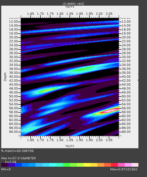
| Estimated Moho Depth: |
57.0 km |
| Estimated Crust Vp/Vs: |
2.06 |
| Assumed Crust Vp: |
6.419 km/s |
| Estimated Crust Vs: |
3.116 km/s |
| Estimated Crust Poisson's Ratio: |
0.35 |
|
| Radial Match: |
80.069786 % |
| Radial Bump: |
391 |
| Transverse Match: |
78.725914 % |
| Transverse Bump: |
400 |
| SOD ConfigId: |
13570011 |
| Insert Time: |
2019-05-01 11:46:30.250 +0000 |
| GWidth: |
2.5 |
| Max Bumps: |
400 |
| Tol: |
0.001 |
|

Signal To Noise
| Channel | StoN | STA | LTA |
| LD:BMNY: :HHZ:20181010T23:27:18.210022Z | 4.4209337 | 2.1634396E-6 | 4.8936266E-7 |
| LD:BMNY: :HHN:20181010T23:27:18.210022Z | 2.8771236 | 5.3908605E-7 | 1.8736978E-7 |
| LD:BMNY: :HHE:20181010T23:27:18.210022Z | 2.7683403 | 4.9174236E-7 | 1.7763074E-7 |
| Arrivals |
| Ps | 9.7 SECOND |
| PpPs | 26 SECOND |
| PsPs/PpSs | 36 SECOND |


