You are here: Home > Network List > N4 - Central and EAstern US Network Stations List
> Station H62A Milan, NH, USA > Earthquake Result Viewer
H62A Milan, NH, USA - Earthquake Result Viewer
| Earthquake location: |
Kuril Islands |
| Earthquake latitude/longitude: |
49.1/156.4 |
| Earthquake time(UTC): |
2018/10/10 (283) 23:16:04 GMT |
| Earthquake Depth: |
33 km |
| Earthquake Magnitude: |
6.8 Mi |
| Earthquake Catalog/Contributor: |
NEIC PDE/at |
|
| Network: |
N4 Central and EAstern US Network |
| Station: |
H62A Milan, NH, USA |
| Lat/Lon: |
44.57 N/71.16 W |
| Elevation: |
381 m |
|
| Distance: |
77.9 deg |
| Az: |
32.646 deg |
| Baz: |
330.259 deg |
| Ray Param: |
0.04998244 |
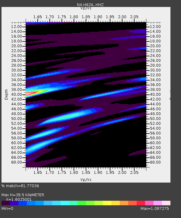
| Estimated Moho Depth: |
39.5 km |
| Estimated Crust Vp/Vs: |
1.60 |
| Assumed Crust Vp: |
6.419 km/s |
| Estimated Crust Vs: |
4.006 km/s |
| Estimated Crust Poisson's Ratio: |
0.18 |
|
| Radial Match: |
91.77036 % |
| Radial Bump: |
400 |
| Transverse Match: |
69.68114 % |
| Transverse Bump: |
400 |
| SOD ConfigId: |
13570011 |
| Insert Time: |
2019-05-01 11:47:31.728 +0000 |
| GWidth: |
2.5 |
| Max Bumps: |
400 |
| Tol: |
0.001 |
|

Signal To Noise
| Channel | StoN | STA | LTA |
| N4:H62A: :HHZ:20181010T23:27:26.299988Z | 9.674045 | 2.4893693E-6 | 2.5732456E-7 |
| N4:H62A: :HHN:20181010T23:27:26.299988Z | 5.986412 | 1.1601855E-6 | 1.9380315E-7 |
| N4:H62A: :HHE:20181010T23:27:26.299988Z | 2.7007577 | 6.057251E-7 | 2.242797E-7 |
| Arrivals |
| Ps | 3.8 SECOND |
| PpPs | 15 SECOND |
| PsPs/PpSs | 19 SECOND |


