You are here: Home > Network List > TA - USArray Transportable Network (new EarthScope stations) Stations List
> Station I14A Mackay, ID, USA > Earthquake Result Viewer
I14A Mackay, ID, USA - Earthquake Result Viewer
| Earthquake location: |
Near Coast Of Guatemala |
| Earthquake latitude/longitude: |
13.6/-90.6 |
| Earthquake time(UTC): |
2008/04/15 (106) 03:03:04 GMT |
| Earthquake Depth: |
33 km |
| Earthquake Magnitude: |
5.6 MB, 5.8 MS, 6.1 MW, 6.1 MW |
| Earthquake Catalog/Contributor: |
WHDF/NEIC |
|
| Network: |
TA USArray Transportable Network (new EarthScope stations) |
| Station: |
I14A Mackay, ID, USA |
| Lat/Lon: |
43.93 N/113.45 W |
| Elevation: |
1897 m |
|
| Distance: |
36.0 deg |
| Az: |
331.515 deg |
| Baz: |
140.066 deg |
| Ray Param: |
0.07683532 |
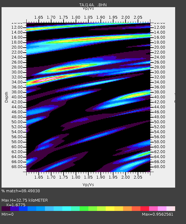
| Estimated Moho Depth: |
32.75 km |
| Estimated Crust Vp/Vs: |
1.68 |
| Assumed Crust Vp: |
6.279 km/s |
| Estimated Crust Vs: |
3.743 km/s |
| Estimated Crust Poisson's Ratio: |
0.22 |
|
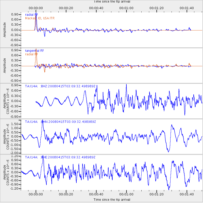
| Radial Match: |
89.49838 % |
| Radial Bump: |
400 |
| Transverse Match: |
41.774414 % |
| Transverse Bump: |
400 |
| SOD ConfigId: |
2504 |
| Insert Time: |
2010-03-06 16:44:09.655 +0000 |
| GWidth: |
2.5 |
| Max Bumps: |
400 |
| Tol: |
0.001 |
|
Signal To Noise
| Channel | StoN | STA | LTA |
| TA:I14A: :BHN:20080415T03:09:32.498989Z | 5.1231866 | 8.801827E-7 | 1.7180376E-7 |
| TA:I14A: :BHE:20080415T03:09:32.498989Z | 4.2554827 | 4.3220984E-7 | 1.0156541E-7 |
| TA:I14A: :BHZ:20080415T03:09:32.498989Z | 2.1721141 | 3.510238E-7 | 1.6160467E-7 |
| Arrivals |
| Ps | 3.8 SECOND |
| PpPs | 13 SECOND |
| PsPs/PpSs | 17 SECOND |


