You are here: Home > Network List > TA - USArray Transportable Network (new EarthScope stations) Stations List
> Station I14A Mackay, ID, USA > Earthquake Result Viewer
I14A Mackay, ID, USA - Earthquake Result Viewer
| Earthquake location: |
Near East Coast Of Honshu, Japan |
| Earthquake latitude/longitude: |
36.2/141.8 |
| Earthquake time(UTC): |
2008/05/07 (128) 16:16:36 GMT |
| Earthquake Depth: |
23 km |
| Earthquake Magnitude: |
5.9 MB, 6.1 MW, 6.0 MW |
| Earthquake Catalog/Contributor: |
WHDF/NEIC |
|
| Network: |
TA USArray Transportable Network (new EarthScope stations) |
| Station: |
I14A Mackay, ID, USA |
| Lat/Lon: |
43.93 N/113.45 W |
| Elevation: |
1897 m |
|
| Distance: |
75.1 deg |
| Az: |
46.288 deg |
| Baz: |
305.941 deg |
| Ray Param: |
0.05185427 |
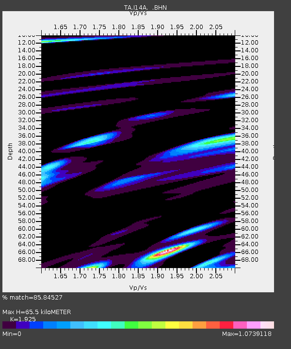
| Estimated Moho Depth: |
65.5 km |
| Estimated Crust Vp/Vs: |
1.92 |
| Assumed Crust Vp: |
6.279 km/s |
| Estimated Crust Vs: |
3.262 km/s |
| Estimated Crust Poisson's Ratio: |
0.32 |
|
| Radial Match: |
85.84527 % |
| Radial Bump: |
400 |
| Transverse Match: |
74.55006 % |
| Transverse Bump: |
400 |
| SOD ConfigId: |
2504 |
| Insert Time: |
2010-03-06 16:44:19.554 +0000 |
| GWidth: |
2.5 |
| Max Bumps: |
400 |
| Tol: |
0.001 |
|

Signal To Noise
| Channel | StoN | STA | LTA |
| TA:I14A: :BHN:20080507T16:27:45.07501Z | 1.1768048 | 4.754332E-7 | 4.0400346E-7 |
| TA:I14A: :BHE:20080507T16:27:45.07501Z | 0.86253417 | 2.311373E-7 | 2.6797466E-7 |
| TA:I14A: :BHZ:20080507T16:27:45.07501Z | 2.5924366 | 6.734928E-7 | 2.5979145E-7 |
| Arrivals |
| Ps | 9.9 SECOND |
| PpPs | 30 SECOND |
| PsPs/PpSs | 40 SECOND |


