You are here: Home > Network List > TS - TERRAscope (Southern California Seismic Network) Stations List
> Station BAR Barrett Dam, California, USA > Earthquake Result Viewer
BAR Barrett Dam, California, USA - Earthquake Result Viewer
| Earthquake location: |
New Britain Region, P.N.G. |
| Earthquake latitude/longitude: |
-4.8/151.5 |
| Earthquake time(UTC): |
1995/08/14 (226) 04:37:17 GMT |
| Earthquake Depth: |
126 km |
| Earthquake Magnitude: |
6.3 MB, 6.3 MS, 6.4 UNKNOWN |
| Earthquake Catalog/Contributor: |
WHDF/NEIC |
|
| Network: |
TS TERRAscope (Southern California Seismic Network) |
| Station: |
BAR Barrett Dam, California, USA |
| Lat/Lon: |
32.68 N/116.67 W |
| Elevation: |
548 m |
|
| Distance: |
94.1 deg |
| Az: |
57.681 deg |
| Baz: |
266.927 deg |
| Ray Param: |
0.041038066 |
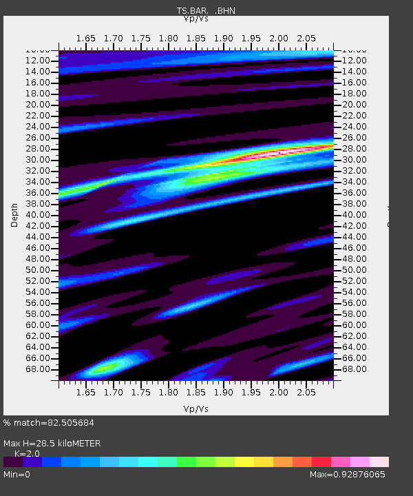
| Estimated Moho Depth: |
28.5 km |
| Estimated Crust Vp/Vs: |
2.00 |
| Assumed Crust Vp: |
6.264 km/s |
| Estimated Crust Vs: |
3.132 km/s |
| Estimated Crust Poisson's Ratio: |
0.33 |
|
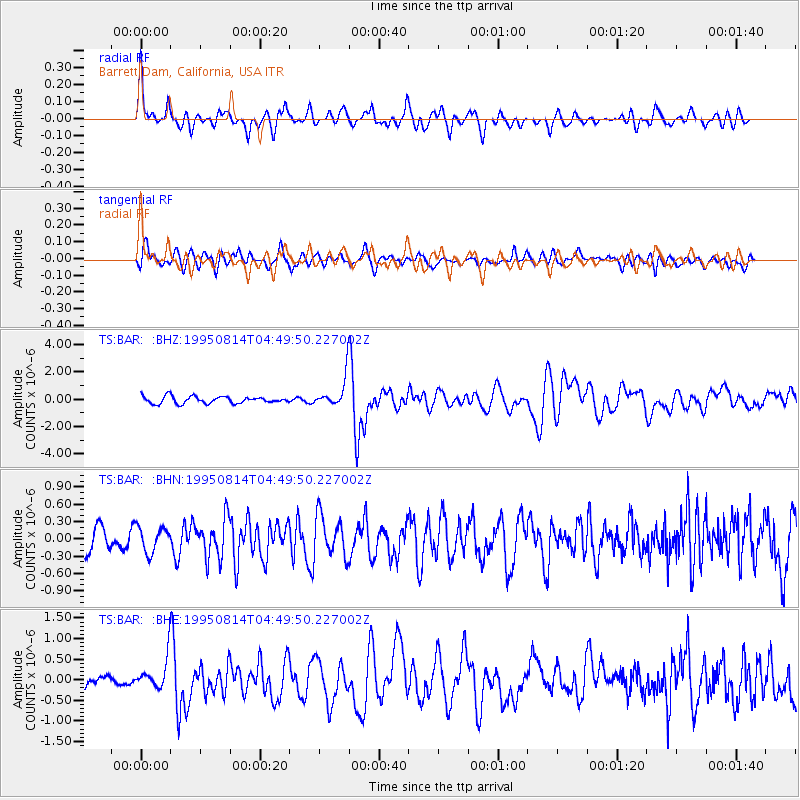
| Radial Match: |
82.505684 % |
| Radial Bump: |
400 |
| Transverse Match: |
65.12322 % |
| Transverse Bump: |
400 |
| SOD ConfigId: |
6273 |
| Insert Time: |
2010-02-26 13:58:23.608 +0000 |
| GWidth: |
2.5 |
| Max Bumps: |
400 |
| Tol: |
0.001 |
|
Signal To Noise
| Channel | StoN | STA | LTA |
| TS:BAR: :BHN:19950814T04:49:50.227002Z | 0.61990887 | 2.2404585E-7 | 3.614174E-7 |
| TS:BAR: :BHE:19950814T04:49:50.227002Z | 3.3117692 | 3.778999E-7 | 1.14108154E-7 |
| TS:BAR: :BHZ:19950814T04:49:50.227002Z | 4.317083 | 1.0906119E-6 | 2.5262705E-7 |
| Arrivals |
| Ps | 4.6 SECOND |
| PpPs | 13 SECOND |
| PsPs/PpSs | 18 SECOND |


