You are here: Home > Network List > N4 - Central and EAstern US Network Stations List
> Station TUL3 Leonard, OK, USA > Earthquake Result Viewer
TUL3 Leonard, OK, USA - Earthquake Result Viewer
| Earthquake location: |
Kuril Islands |
| Earthquake latitude/longitude: |
49.1/156.4 |
| Earthquake time(UTC): |
2018/10/10 (283) 23:16:04 GMT |
| Earthquake Depth: |
33 km |
| Earthquake Magnitude: |
6.8 Mi |
| Earthquake Catalog/Contributor: |
NEIC PDE/at |
|
| Network: |
N4 Central and EAstern US Network |
| Station: |
TUL3 Leonard, OK, USA |
| Lat/Lon: |
35.91 N/95.79 W |
| Elevation: |
265 m |
|
| Distance: |
73.9 deg |
| Az: |
53.548 deg |
| Baz: |
319.366 deg |
| Ray Param: |
0.05263095 |
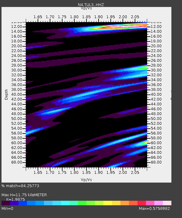
| Estimated Moho Depth: |
11.75 km |
| Estimated Crust Vp/Vs: |
1.99 |
| Assumed Crust Vp: |
6.498 km/s |
| Estimated Crust Vs: |
3.269 km/s |
| Estimated Crust Poisson's Ratio: |
0.33 |
|
| Radial Match: |
84.25773 % |
| Radial Bump: |
362 |
| Transverse Match: |
59.739456 % |
| Transverse Bump: |
400 |
| SOD ConfigId: |
13570011 |
| Insert Time: |
2019-05-01 11:48:32.362 +0000 |
| GWidth: |
2.5 |
| Max Bumps: |
400 |
| Tol: |
0.001 |
|

Signal To Noise
| Channel | StoN | STA | LTA |
| N4:TUL3: :HHZ:20181010T23:27:04.190002Z | 4.2963753 | 1.1444392E-6 | 2.6637318E-7 |
| N4:TUL3: :HHN:20181010T23:27:04.190002Z | 1.8904206 | 4.6018783E-7 | 2.4343146E-7 |
| N4:TUL3: :HHE:20181010T23:27:04.190002Z | 1.7545923 | 3.6941313E-7 | 2.1054073E-7 |
| Arrivals |
| Ps | 1.8 SECOND |
| PpPs | 5.2 SECOND |
| PsPs/PpSs | 7.1 SECOND |


