You are here: Home > Network List > O2 - Oklahoma Consolidated Temporary Seismic Networks Stations List
> Station PERY Perry, Oklahoma, USA > Earthquake Result Viewer
PERY Perry, Oklahoma, USA - Earthquake Result Viewer
| Earthquake location: |
Kuril Islands |
| Earthquake latitude/longitude: |
49.1/156.4 |
| Earthquake time(UTC): |
2018/10/10 (283) 23:16:04 GMT |
| Earthquake Depth: |
33 km |
| Earthquake Magnitude: |
6.8 Mi |
| Earthquake Catalog/Contributor: |
NEIC PDE/at |
|
| Network: |
O2 Oklahoma Consolidated Temporary Seismic Networks |
| Station: |
PERY Perry, Oklahoma, USA |
| Lat/Lon: |
36.26 N/97.24 W |
| Elevation: |
209 m |
|
| Distance: |
72.9 deg |
| Az: |
54.231 deg |
| Baz: |
318.714 deg |
| Ray Param: |
0.05331341 |
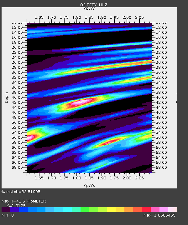
| Estimated Moho Depth: |
41.5 km |
| Estimated Crust Vp/Vs: |
1.81 |
| Assumed Crust Vp: |
6.483 km/s |
| Estimated Crust Vs: |
3.577 km/s |
| Estimated Crust Poisson's Ratio: |
0.28 |
|
| Radial Match: |
83.51095 % |
| Radial Bump: |
400 |
| Transverse Match: |
72.30372 % |
| Transverse Bump: |
400 |
| SOD ConfigId: |
13570011 |
| Insert Time: |
2019-05-01 11:49:17.907 +0000 |
| GWidth: |
2.5 |
| Max Bumps: |
400 |
| Tol: |
0.001 |
|

Signal To Noise
| Channel | StoN | STA | LTA |
| O2:PERY: :HHZ:20181010T23:26:58.143982Z | 2.2126498 | 1.0220828E-6 | 4.61927E-7 |
| O2:PERY: :HH1:20181010T23:26:58.143982Z | 1.7454743 | 4.0889708E-7 | 2.3426131E-7 |
| O2:PERY: :HH2:20181010T23:26:58.143982Z | 1.1078027 | 3.976239E-7 | 3.5893024E-7 |
| Arrivals |
| Ps | 5.4 SECOND |
| PpPs | 17 SECOND |
| PsPs/PpSs | 23 SECOND |


