You are here: Home > Network List > PF - Volcanologic Network of Piton de Fournaise-OVPF Stations List
> Station CIL Cilaos (Pompiers) > Earthquake Result Viewer
CIL Cilaos (Pompiers) - Earthquake Result Viewer
| Earthquake location: |
Mariana Islands |
| Earthquake latitude/longitude: |
18.5/145.5 |
| Earthquake time(UTC): |
2016/07/29 (211) 21:18:25 GMT |
| Earthquake Depth: |
212 km |
| Earthquake Magnitude: |
7.7 MWW, 7.7 MWB, 7.7 MI |
| Earthquake Catalog/Contributor: |
NEIC PDE/NEIC COMCAT |
|
| Network: |
PF Volcanologic Network of Piton de Fournaise-OVPF |
| Station: |
CIL Cilaos (Pompiers) |
| Lat/Lon: |
21.13 S/55.47 E |
| Elevation: |
1223 m |
|
| Distance: |
96.5 deg |
| Az: |
249.998 deg |
| Baz: |
72.768 deg |
| Ray Param: |
0.04029087 |
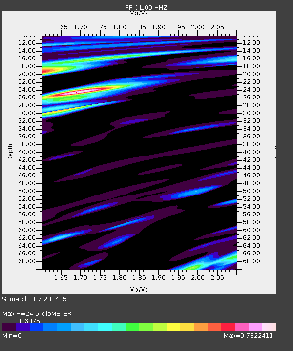
| Estimated Moho Depth: |
24.5 km |
| Estimated Crust Vp/Vs: |
1.69 |
| Assumed Crust Vp: |
4.73 km/s |
| Estimated Crust Vs: |
2.803 km/s |
| Estimated Crust Poisson's Ratio: |
0.23 |
|
| Radial Match: |
87.231415 % |
| Radial Bump: |
400 |
| Transverse Match: |
59.635506 % |
| Transverse Bump: |
400 |
| SOD ConfigId: |
1634031 |
| Insert Time: |
2016-08-12 21:33:14.556 +0000 |
| GWidth: |
2.5 |
| Max Bumps: |
400 |
| Tol: |
0.001 |
|
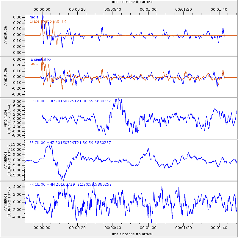
Signal To Noise
| Channel | StoN | STA | LTA |
| PF:CIL:00:HHZ:20160729T21:30:59.588025Z | 9.939066 | 1.0126886E-5 | 1.018897E-6 |
| PF:CIL:00:HHN:20160729T21:30:59.588025Z | 1.1740324 | 1.7143097E-6 | 1.4601894E-6 |
| PF:CIL:00:HHE:20160729T21:30:59.588025Z | 3.913158 | 3.8884073E-6 | 9.93675E-7 |
| Arrivals |
| Ps | 3.6 SECOND |
| PpPs | 14 SECOND |
| PsPs/PpSs | 17 SECOND |


