You are here: Home > Network List > PF - Volcanologic Network of Piton de Fournaise-OVPF Stations List
> Station HIM cratere Himiltrude > Earthquake Result Viewer
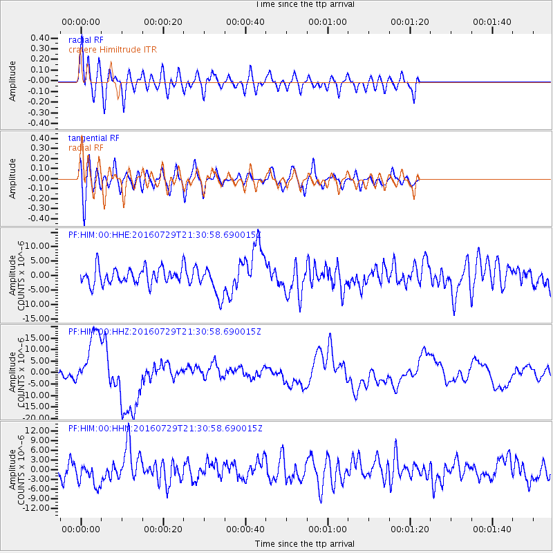
HIM cratere Himiltrude - Earthquake Result Viewer
*The percent match for this event was below the threshold and hence no stack was calculated.
| Earthquake location: |
Mariana Islands |
| Earthquake latitude/longitude: |
18.5/145.5 |
| Earthquake time(UTC): |
2016/07/29 (211) 21:18:25 GMT |
| Earthquake Depth: |
212 km |
| Earthquake Magnitude: |
7.7 MWW, 7.7 MWB, 7.7 MI |
| Earthquake Catalog/Contributor: |
NEIC PDE/NEIC COMCAT |
|
| Network: |
PF Volcanologic Network of Piton de Fournaise-OVPF |
| Station: |
HIM cratere Himiltrude |
| Lat/Lon: |
21.21 S/55.72 E |
| Elevation: |
1958 m |
|
| Distance: |
96.3 deg |
| Az: |
249.855 deg |
| Baz: |
72.694 deg |
| Ray Param: |
$rayparam |
*The percent match for this event was below the threshold and hence was not used in the summary stack. |
|
| Radial Match: |
74.234375 % |
| Radial Bump: |
400 |
| Transverse Match: |
51.216236 % |
| Transverse Bump: |
400 |
| SOD ConfigId: |
1634031 |
| Insert Time: |
2016-08-12 21:33:45.537 +0000 |
| GWidth: |
2.5 |
| Max Bumps: |
400 |
| Tol: |
0.001 |
|
Signal To Noise
| Channel | StoN | STA | LTA |
| PF:HIM:00:HHZ:20160729T21:30:58.690015Z | 9.818706 | 1.2877401E-5 | 1.3115172E-6 |
| PF:HIM:00:HHN:20160729T21:30:58.690015Z | 1.7610267 | 3.7333025E-6 | 2.119958E-6 |
| PF:HIM:00:HHE:20160729T21:30:58.690015Z | 2.028784 | 5.5054397E-6 | 2.7136648E-6 |
| Arrivals |
| Ps | |
| PpPs | |
| PsPs/PpSs | |


