You are here: Home > Network List > TA - USArray Transportable Network (new EarthScope stations) Stations List
> Station I14A Mackay, ID, USA > Earthquake Result Viewer
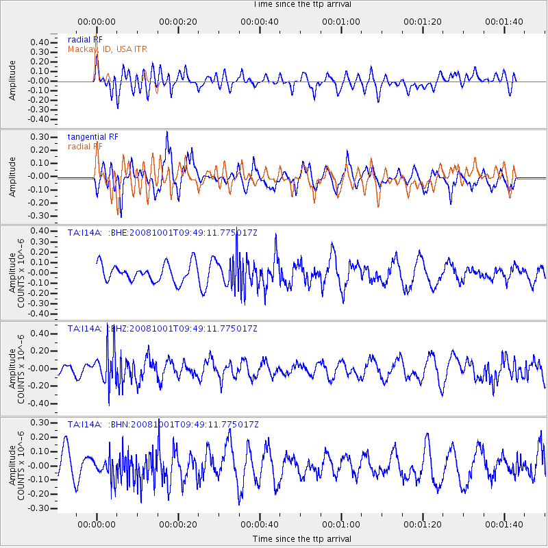
I14A Mackay, ID, USA - Earthquake Result Viewer
*The percent match for this event was below the threshold and hence no stack was calculated.
| Earthquake location: |
Southeast Of Honshu, Japan |
| Earthquake latitude/longitude: |
30.2/138.8 |
| Earthquake time(UTC): |
2008/10/01 (275) 09:38:12 GMT |
| Earthquake Depth: |
414 km |
| Earthquake Magnitude: |
5.7 MW, 5.1 MB, 5.7 MW |
| Earthquake Catalog/Contributor: |
WHDF/NEIC |
|
| Network: |
TA USArray Transportable Network (new EarthScope stations) |
| Station: |
I14A Mackay, ID, USA |
| Lat/Lon: |
43.93 N/113.45 W |
| Elevation: |
1897 m |
|
| Distance: |
81.1 deg |
| Az: |
44.143 deg |
| Baz: |
303.407 deg |
| Ray Param: |
$rayparam |
*The percent match for this event was below the threshold and hence was not used in the summary stack. |
|
| Radial Match: |
59.773113 % |
| Radial Bump: |
400 |
| Transverse Match: |
60.084164 % |
| Transverse Bump: |
358 |
| SOD ConfigId: |
2556 |
| Insert Time: |
2010-03-06 16:45:07.043 +0000 |
| GWidth: |
2.5 |
| Max Bumps: |
400 |
| Tol: |
0.001 |
|
Signal To Noise
| Channel | StoN | STA | LTA |
| TA:I14A: :BHZ:20081001T09:49:11.775017Z | 2.9830213 | 1.9553043E-7 | 6.554778E-8 |
| TA:I14A: :BHN:20081001T09:49:11.775017Z | 0.9606377 | 7.333747E-8 | 7.634248E-8 |
| TA:I14A: :BHE:20081001T09:49:11.775017Z | 1.6266302 | 1.3679129E-7 | 8.4094886E-8 |
| Arrivals |
| Ps | |
| PpPs | |
| PsPs/PpSs | |


