You are here: Home > Network List > TA - USArray Transportable Network (new EarthScope stations) Stations List
> Station G31M Satah River, YT, CAN > Earthquake Result Viewer
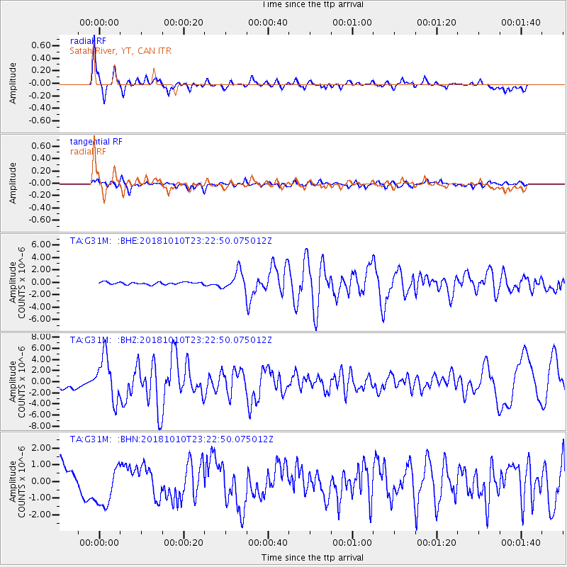
G31M Satah River, YT, CAN - Earthquake Result Viewer
*The percent match for this event was below the threshold and hence no stack was calculated.
| Earthquake location: |
Kuril Islands |
| Earthquake latitude/longitude: |
49.1/156.4 |
| Earthquake time(UTC): |
2018/10/10 (283) 23:16:04 GMT |
| Earthquake Depth: |
33 km |
| Earthquake Magnitude: |
6.8 Mi |
| Earthquake Catalog/Contributor: |
NEIC PDE/at |
|
| Network: |
TA USArray Transportable Network (new EarthScope stations) |
| Station: |
G31M Satah River, YT, CAN |
| Lat/Lon: |
66.92 N/134.27 W |
| Elevation: |
61 m |
|
| Distance: |
38.4 deg |
| Az: |
36.461 deg |
| Baz: |
277.767 deg |
| Ray Param: |
$rayparam |
*The percent match for this event was below the threshold and hence was not used in the summary stack. |
|
| Radial Match: |
88.461716 % |
| Radial Bump: |
373 |
| Transverse Match: |
54.800262 % |
| Transverse Bump: |
400 |
| SOD ConfigId: |
13570011 |
| Insert Time: |
2019-05-01 11:51:28.002 +0000 |
| GWidth: |
2.5 |
| Max Bumps: |
400 |
| Tol: |
0.001 |
|
Signal To Noise
| Channel | StoN | STA | LTA |
| TA:G31M: :BHZ:20181010T23:22:50.075012Z | 6.4090114 | 4.1105754E-6 | 6.413743E-7 |
| TA:G31M: :BHN:20181010T23:22:50.075012Z | 1.4438642 | 1.284746E-6 | 8.897969E-7 |
| TA:G31M: :BHE:20181010T23:22:50.075012Z | 12.81025 | 2.3734938E-6 | 1.8528083E-7 |
| Arrivals |
| Ps | |
| PpPs | |
| PsPs/PpSs | |


