You are here: Home > Network List > TA - USArray Transportable Network (new EarthScope stations) Stations List
> Station H31M Peel River, Yukon, CAN > Earthquake Result Viewer
H31M Peel River, Yukon, CAN - Earthquake Result Viewer
| Earthquake location: |
Kuril Islands |
| Earthquake latitude/longitude: |
49.1/156.4 |
| Earthquake time(UTC): |
2018/10/10 (283) 23:16:04 GMT |
| Earthquake Depth: |
33 km |
| Earthquake Magnitude: |
6.8 Mi |
| Earthquake Catalog/Contributor: |
NEIC PDE/at |
|
| Network: |
TA USArray Transportable Network (new EarthScope stations) |
| Station: |
H31M Peel River, Yukon, CAN |
| Lat/Lon: |
65.81 N/134.34 W |
| Elevation: |
642 m |
|
| Distance: |
38.5 deg |
| Az: |
38.254 deg |
| Baz: |
279.107 deg |
| Ray Param: |
0.075463094 |
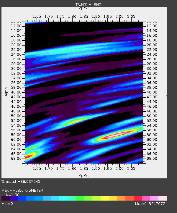
| Estimated Moho Depth: |
58.0 km |
| Estimated Crust Vp/Vs: |
1.98 |
| Assumed Crust Vp: |
6.419 km/s |
| Estimated Crust Vs: |
3.242 km/s |
| Estimated Crust Poisson's Ratio: |
0.33 |
|
| Radial Match: |
86.937645 % |
| Radial Bump: |
400 |
| Transverse Match: |
59.06406 % |
| Transverse Bump: |
400 |
| SOD ConfigId: |
13570011 |
| Insert Time: |
2019-05-01 11:51:32.860 +0000 |
| GWidth: |
2.5 |
| Max Bumps: |
400 |
| Tol: |
0.001 |
|
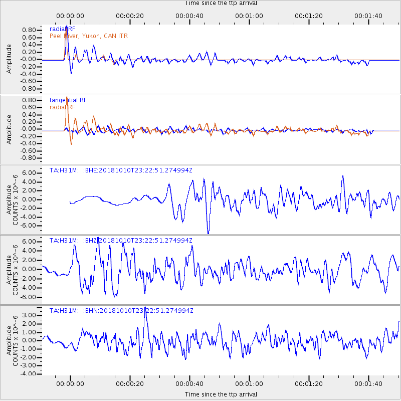
Signal To Noise
| Channel | StoN | STA | LTA |
| TA:H31M: :BHZ:20181010T23:22:51.274994Z | 3.5022948 | 3.0084177E-6 | 8.589847E-7 |
| TA:H31M: :BHN:20181010T23:22:51.274994Z | 2.2149396 | 7.7841315E-7 | 3.5143765E-7 |
| TA:H31M: :BHE:20181010T23:22:51.274994Z | 3.5991576 | 2.4958802E-6 | 6.934623E-7 |
| Arrivals |
| Ps | 9.4 SECOND |
| PpPs | 25 SECOND |
| PsPs/PpSs | 35 SECOND |


