You are here: Home > Network List > TA - USArray Transportable Network (new EarthScope stations) Stations List
> Station M31M Drury Creek, Yukon, CA > Earthquake Result Viewer
M31M Drury Creek, Yukon, CA - Earthquake Result Viewer
| Earthquake location: |
Kuril Islands |
| Earthquake latitude/longitude: |
49.1/156.4 |
| Earthquake time(UTC): |
2018/10/10 (283) 23:16:04 GMT |
| Earthquake Depth: |
33 km |
| Earthquake Magnitude: |
6.8 Mi |
| Earthquake Catalog/Contributor: |
NEIC PDE/at |
|
| Network: |
TA USArray Transportable Network (new EarthScope stations) |
| Station: |
M31M Drury Creek, Yukon, CA |
| Lat/Lon: |
62.20 N/134.39 W |
| Elevation: |
639 m |
|
| Distance: |
39.2 deg |
| Az: |
43.919 deg |
| Baz: |
283.477 deg |
| Ray Param: |
0.075065926 |
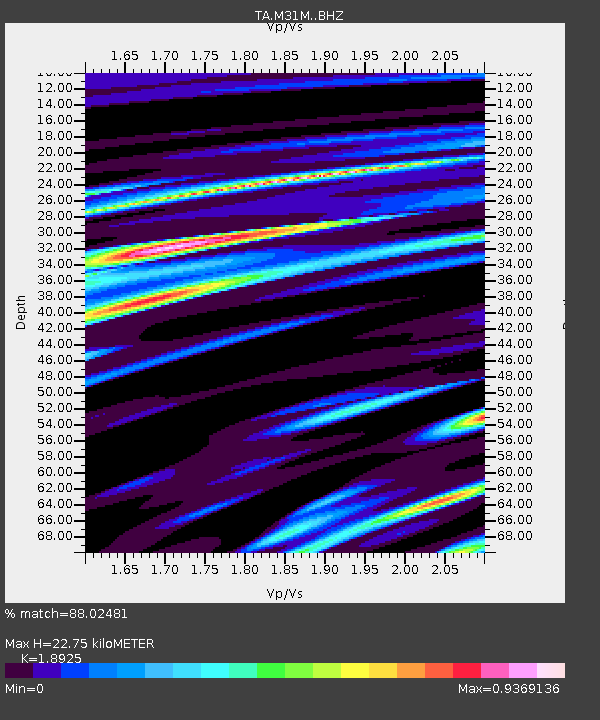
| Estimated Moho Depth: |
22.75 km |
| Estimated Crust Vp/Vs: |
1.89 |
| Assumed Crust Vp: |
6.419 km/s |
| Estimated Crust Vs: |
3.392 km/s |
| Estimated Crust Poisson's Ratio: |
0.31 |
|
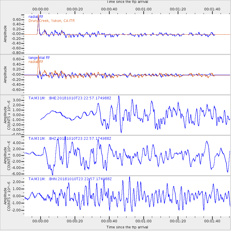
| Radial Match: |
88.02481 % |
| Radial Bump: |
400 |
| Transverse Match: |
72.462845 % |
| Transverse Bump: |
400 |
| SOD ConfigId: |
13570011 |
| Insert Time: |
2019-05-01 11:51:41.017 +0000 |
| GWidth: |
2.5 |
| Max Bumps: |
400 |
| Tol: |
0.001 |
|
Signal To Noise
| Channel | StoN | STA | LTA |
| TA:M31M: :BHZ:20181010T23:22:57.174988Z | 2.084676 | 1.7334951E-6 | 8.315417E-7 |
| TA:M31M: :BHN:20181010T23:22:57.174988Z | 1.1495335 | 3.0526942E-7 | 2.6555938E-7 |
| TA:M31M: :BHE:20181010T23:22:57.174988Z | 2.2731616 | 1.29474E-6 | 5.695767E-7 |
| Arrivals |
| Ps | 3.4 SECOND |
| PpPs | 9.6 SECOND |
| PsPs/PpSs | 13 SECOND |


